Geolokalisieren
👉 Easily get elevation data in JSON, GeoTIFF and KML formats using Elevation API
Vielen Dank für die Unterstützung dieser Website ❤️
Spenden

Topografische Karte Adams

Klicken Sie auf die Karte, um die Höhe anzuzeigen.

👉 Easily get elevation data in JSON, GeoTIFF and KML formats using Elevation API
Vielen Dank für die Unterstützung dieser Website ❤️
Spenden

Adams

The shield was derived from the Provincial Seal of Ilocos Norte. The mountain range and the verdant field and river show the topography of the place as a potential source of wealth and livelihood. The mountain ranges also symbolizes the lofty ideals and the high hopes of the people for making Adams a progressive and attractive place to live in.

Wikipedia (CC-BY-SA 3.0)

👉 Easily get elevation data in JSON, GeoTIFF and KML formats using Elevation API
Vielen Dank für die Unterstützung dieser Website ❤️
Spenden

Über diese Karte

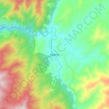
Name: Topografische Karte Adams, Höhe, Relief.

Ort: Adams, Ilocos Norte, Ilocos Region, 2922, Philippines (18.42131 120.86357 18.50131 120.94357)

Durchschnittliche Höhe: 517 m

Minimale Höhe: 153 m

Maximale Höhe: 1.185 m

👉 Easily get elevation data in JSON, GeoTIFF and KML formats using Elevation API
Vielen Dank für die Unterstützung dieser Website ❤️
Spenden

Andere topografische Karten

Klicken Sie auf eine Karte, um ihre Topografie, ihre Höhe und ihr Relief anzuzeigen.

Brgy. 11

Philippines > Ilocos Norte

Durchschnittliche Höhe: 11 m

Kapurpurawan Rock Formation

Philippines > Ilocos Norte

Durchschnittliche Höhe: 23 m

Pinili

Philippines > Ilocos Norte

Durchschnittliche Höhe: 69 m

Pagudpud

Philippines > Ilocos Norte

The town's topography includes mountains, hills, valleys and flat coastal land.

Durchschnittliche Höhe: 71 m

Vielen Dank für die Unterstützung dieser Website ❤️
Spenden

Brgy. 43- Cavit

Philippines > Ilocos Norte

Durchschnittliche Höhe: 4 m

Brgy. 6

Philippines > Ilocos Norte

Durchschnittliche Höhe: 10 m

Bojeador Cape

Philippines > Ilocos Norte

Durchschnittliche Höhe: 114 m

Badoc Island

Philippines > Ilocos Norte

Durchschnittliche Höhe: 1 m

Vielen Dank für die Unterstützung dieser Website ❤️
Spenden

Luna Park

Philippines > Ilocos Norte > Garreta

Durchschnittliche Höhe: 16 m

Paoay Sand Dune

Philippines > Ilocos Norte > Bgy. 37 Calayab > Calayab

Durchschnittliche Höhe: 9 m

Madongan Dam (Papa Dam)

Philippines > Ilocos Norte > Cacafean

Durchschnittliche Höhe: 218 m

Laoag

Philippines > Ilocos Norte > Brgy. 32-A La Paz East

Durchschnittliche Höhe: 13 m

Vielen Dank für die Unterstützung dieser Website ❤️
Spenden

Saud Beach

Philippines > Ilocos Norte > Pagudpud > Saud

Durchschnittliche Höhe: 11 m

Gasgas River

Philippines > Ilocos Norte > Foz

Durchschnittliche Höhe: 219 m

Laoag

Philippines > Ilocos Norte > Brgy. 32-A La Paz East

Durchschnittliche Höhe: 13 m

Paoay Lake

Philippines > Ilocos Norte > Suba

Durchschnittliche Höhe: 26 m

Vielen Dank für die Unterstützung dieser Website ❤️
Spenden

Pinili

Philippines > Ilocos Norte

Durchschnittliche Höhe: 69 m

Pinili

Philippines > Ilocos Norte

Durchschnittliche Höhe: 69 m

Brgy. 1

Philippines > Ilocos Norte

Durchschnittliche Höhe: 10 m

Vielen Dank für die Unterstützung dieser Website ❤️
Spenden

Padsan River

Philippines > Ilocos Norte > Brgy. 53- Rioeng

Durchschnittliche Höhe: 90 m

Saud Beach

Philippines > Ilocos Norte > Pagudpud > Saud

Durchschnittliche Höhe: 11 m

Pagudpud

Philippines > Ilocos Norte

The town's topography includes mountains, hills, valleys and flat coastal land.

Durchschnittliche Höhe: 73 m