Geolokalisieren
👉 Easily get elevation data in JSON, GeoTIFF and KML formats using Elevation API
Vielen Dank für die Unterstützung dieser Website ❤️
Spenden

Topografische Karte Souto Maior

Klicken Sie auf die Karte, um die Höhe anzuzeigen.

👉 Easily get elevation data in JSON, GeoTIFF and KML formats using Elevation API
Vielen Dank für die Unterstützung dieser Website ❤️
Spenden

Über diese Karte

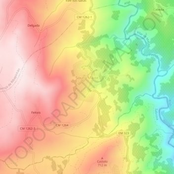
Name: Topografische Karte Souto Maior, Höhe, Relief.

Ort: Souto Maior, Sabrosa, Vila Real, Portugal (41.27243 -7.60837 41.30738 -7.55959)

Durchschnittliche Höhe: 594 m

Minimale Höhe: 262 m

Maximale Höhe: 845 m

👉 Easily get elevation data in JSON, GeoTIFF and KML formats using Elevation API
Vielen Dank für die Unterstützung dieser Website ❤️
Spenden

Andere topografische Karten

Klicken Sie auf eine Karte, um ihre Topografie, ihre Höhe und ihr Relief anzuzeigen.

Fermentões

Portugal > Vila Real > Sabrosa > Paços

Durchschnittliche Höhe: 635 m

Donelo

Portugal > Vila Real > Sabrosa > Covas do Douro

Durchschnittliche Höhe: 473 m

Paradela de Guiães

Portugal > Vila Real > Sabrosa

Durchschnittliche Höhe: 553 m

Vielen Dank für die Unterstützung dieser Website ❤️
Spenden

Pinhão Cel

Portugal > Vila Real > Sabrosa > Torre do Pinhão

Durchschnittliche Höhe: 765 m

Infantado

Portugal > Vila Real > Sabrosa

Durchschnittliche Höhe: 682 m

Saudel

Portugal > Vila Real > Sabrosa > São Lourenço de Ribapinhão

Durchschnittliche Höhe: 661 m

Pesinho

Portugal > Vila Real > Sabrosa > Covas do Douro

Durchschnittliche Höhe: 285 m

Vielen Dank für die Unterstützung dieser Website ❤️
Spenden

Assento de Paços

Portugal > Vila Real > Sabrosa > Paços

Durchschnittliche Höhe: 623 m

Gouvães do Douro

Portugal > Vila Real > Sabrosa

Durchschnittliche Höhe: 415 m