
Topografische Karte Apies
Interaktive Karte
Klicken Sie auf die Karte, um die Höhe anzuzeigen.
Über diese Karte
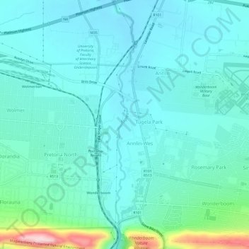
Name: Topografische Karte Apies, Höhe, Relief.
Durchschnittliche Höhe: 1.250 m
Minimale Höhe: 1.205 m
Maximale Höhe: 1.475 m
Andere topografische Karten
Klicken Sie auf eine Karte, um ihre Topografie, ihre Höhe und ihr Relief anzuzeigen.
Kruin Park
South Africa > Gauteng > City of Tshwane Metropolitan Municipality > Pretoria
Kruin Park, Lukasrand, Tshwane Ward 59, Pretoria, City of Tshwane Metropolitan Municipality, Gauteng, South Africa
Durchschnittliche Höhe: 1.380 m
Faerie Glen Nature Reserve
South Africa > Gauteng > City of Tshwane Metropolitan Municipality > Pretoria
Faerie Glen Nature Reserve, Tshwane Ward 46, Pretoria, City of Tshwane Metropolitan Municipality, Gauteng, South Africa
Durchschnittliche Höhe: 1.385 m
Freedom Park
South Africa > Gauteng > City of Tshwane Metropolitan Municipality > Pretoria
Freedom Park, Tshwane Ward 59, Pretoria, City of Tshwane Metropolitan Municipality, Gauteng, South Africa
Durchschnittliche Höhe: 1.390 m
Prince's Park
South Africa > Gauteng > City of Tshwane Metropolitan Municipality > Pretoria
Prince's Park, Salvokop, Tshwane Ward 60, Pretoria, City of Tshwane Metropolitan Municipality, Gauteng, South Africa
Durchschnittliche Höhe: 1.325 m