Geolokalisieren
👉 Easily get elevation data in JSON, GeoTIFF and KML formats using Elevation API
Vielen Dank für die Unterstützung dieser Website ❤️
Spenden

Topografische Karte Pinho

Klicken Sie auf die Karte, um die Höhe anzuzeigen.

👉 Easily get elevation data in JSON, GeoTIFF and KML formats using Elevation API
Vielen Dank für die Unterstützung dieser Website ❤️
Spenden

Pinho

Santa Marta é a sua padroeira, contudo a festa que anualmente se realiza é também em honra de Santa Bárbara. Esta povoação situa se no alto, quase no cume da elevação que tem as vertentes para as ribeiras dos rios Terva e Tâmega. Os montes são sem dúvida, o elemento mais destacado da natureza que muito sensibilizou o homem primitivo, e eles são, na toponomástica, os estratos linguísticos mais antigos, de parceria com os rios.

Wikipedia (CC-BY-SA 3.0)

👉 Easily get elevation data in JSON, GeoTIFF and KML formats using Elevation API
Vielen Dank für die Unterstützung dieser Website ❤️
Spenden

Über diese Karte

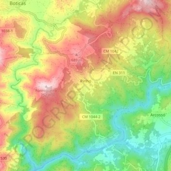
Name: Topografische Karte Pinho, Höhe, Relief.

Ort: Pinho, Boticas, Vila Real, Portugal (41.63026 -7.67307 41.68884 -7.59366)

Durchschnittliche Höhe: 501 m

Minimale Höhe: 289 m

Maximale Höhe: 747 m

👉 Easily get elevation data in JSON, GeoTIFF and KML formats using Elevation API
Vielen Dank für die Unterstützung dieser Website ❤️
Spenden

Andere topografische Karten

Klicken Sie auf eine Karte, um ihre Topografie, ihre Höhe und ihr Relief anzuzeigen.

Pinhal Novo

Portugal > Vila Real > Boticas > Beça

Durchschnittliche Höhe: 785 m

Granja

Portugal > Vila Real > Boticas

Durchschnittliche Höhe: 586 m

Viveiro

Portugal > Vila Real > Boticas

Durchschnittliche Höhe: 938 m

Vilarinho da Mó

Portugal > Vila Real > Boticas > Beça

Durchschnittliche Höhe: 865 m

Vielen Dank für die Unterstützung dieser Website ❤️
Spenden

Quintas

Portugal > Vila Real > Boticas > Beça

Durchschnittliche Höhe: 723 m

Penedo

Portugal > Vila Real > Boticas

Durchschnittliche Höhe: 937 m

Secerigo

Portugal > Vila Real > Boticas

Durchschnittliche Höhe: 784 m

Leiranco

Portugal > Vila Real > Boticas

Durchschnittliche Höhe: 935 m

Vielen Dank für die Unterstützung dieser Website ❤️
Spenden

Bobadela

Portugal > Vila Real > Boticas

Durchschnittliche Höhe: 632 m

Ardãos

Portugal > Vila Real > Boticas

Durchschnittliche Höhe: 678 m

Eiró

Portugal > Vila Real > Boticas

Durchschnittliche Höhe: 627 m

Torneiros

Portugal > Vila Real > Boticas > Beça

Durchschnittliche Höhe: 696 m

Vielen Dank für die Unterstützung dieser Website ❤️
Spenden

Carvalhelhos

Portugal > Vila Real > Boticas > Beça

Durchschnittliche Höhe: 836 m

Covelo do Monte

Portugal > Vila Real > Boticas

Durchschnittliche Höhe: 1.064 m

Serra do Barroso

Portugal > Vila Real > Boticas

Durchschnittliche Höhe: 1.153 m

Vilarinho Seco

Portugal > Vila Real > Boticas

Durchschnittliche Höhe: 960 m

Vielen Dank für die Unterstützung dieser Website ❤️
Spenden

Veral

Portugal > Vila Real > Boticas

Durchschnittliche Höhe: 511 m

Antigo de Curros

Portugal > Vila Real > Boticas

Durchschnittliche Höhe: 773 m

Valdegas

Portugal > Vila Real > Boticas > Pinho

Durchschnittliche Höhe: 532 m

Mosteirão

Portugal > Vila Real > Boticas

Durchschnittliche Höhe: 582 m

Vielen Dank für die Unterstützung dieser Website ❤️
Spenden

Curros

Portugal > Vila Real > Boticas

Durchschnittliche Höhe: 719 m

Carreira da Lebre

Portugal > Vila Real > Boticas > Beça

Durchschnittliche Höhe: 766 m

Cerdedo

Portugal > Vila Real > Boticas > Cerdedo

Durchschnittliche Höhe: 942 m

Alturas do Barroso

Portugal > Vila Real > Boticas

Durchschnittliche Höhe: 1.062 m

Vielen Dank für die Unterstützung dieser Website ❤️
Spenden

Carvalho

Portugal > Vila Real > Boticas

Durchschnittliche Höhe: 897 m

Carvalhelhos

Portugal > Vila Real > Boticas > Beça

Durchschnittliche Höhe: 836 m

Lavradas

Portugal > Vila Real > Boticas > Beça

Durchschnittliche Höhe: 930 m

Alturas do Barroso

Portugal > Vila Real > Boticas

Durchschnittliche Höhe: 1.062 m

Vielen Dank für die Unterstützung dieser Website ❤️
Spenden