Geolokalisieren
👉 Easily get elevation data in JSON, GeoTIFF and KML formats using Elevation API
Vielen Dank für die Unterstützung dieser Website ❤️
Spenden

Topografische Karte Burnley

Klicken Sie auf die Karte, um die Höhe anzuzeigen.

👉 Easily get elevation data in JSON, GeoTIFF and KML formats using Elevation API
Vielen Dank für die Unterstützung dieser Website ❤️
Spenden

Burnley

The town lies in a natural three-forked valley at the confluence of the River Brun and the River Calder, surrounded by open fields, with wild moorland at higher altitudes. To the west of Burnley lie the towns of Padiham, Accrington and Blackburn, with Nelson and Colne to the north. The centre of the town stands at approximately 387 feet (118 m) above sea level and 30 miles (48 km) east of the Irish Sea coast.

Wikipedia (CC-BY-SA 3.0)

👉 Easily get elevation data in JSON, GeoTIFF and KML formats using Elevation API
Vielen Dank für die Unterstützung dieser Website ❤️
Spenden

Über diese Karte

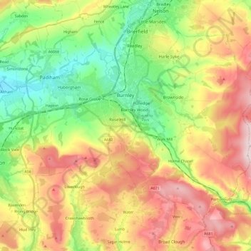
Name: Topografische Karte Burnley, Höhe, Relief.

Ort: Burnley, Lancashire, England, United Kingdom (53.72300 -2.34231 53.82526 -2.11228)

Durchschnittliche Höhe: 247 m

Minimale Höhe: 63 m

Maximale Höhe: 479 m

👉 Easily get elevation data in JSON, GeoTIFF and KML formats using Elevation API
Vielen Dank für die Unterstützung dieser Website ❤️
Spenden

Andere topografische Karten

Klicken Sie auf eine Karte, um ihre Topografie, ihre Höhe und ihr Relief anzuzeigen.

Clougha Pike

United Kingdom > England > Lancashire > Lancaster

Durchschnittliche Höhe: 319 m

Manchester

United Kingdom > England > Lancashire > Manchester

Durchschnittliche Höhe: 118 m

Heysham

United Kingdom > England > Lancashire

Durchschnittliche Höhe: 8 m

Halton

United Kingdom > England > Lancashire > Lancaster

Durchschnittliche Höhe: 60 m

Vielen Dank für die Unterstützung dieser Website ❤️
Spenden

Halton

United Kingdom > England > Lancashire > Lancaster

Durchschnittliche Höhe: 60 m

Accrington

United Kingdom > England > Lancashire > Hyndburn

Geographical coordinates: 53° 46' 0" North, 2° 21' 0" West. Height above sea level: there is a spot height outside the Market Hall which is 133.5 metres (438 ft) the benchmark on the side of the neighbouring Town Hall is 441.10 feet (134.45 m). The highest height in the town is 320 metres (1,050 ft) which is…

Durchschnittliche Höhe: 199 m

Pendle Hill

United Kingdom > England > Lancashire > Borough of Pendle

Durchschnittliche Höhe: 385 m

Skelmersdale

United Kingdom > England > Lancashire > West Lancashire

Durchschnittliche Höhe: 76 m

Vielen Dank für die Unterstützung dieser Website ❤️
Spenden

Hardhorn

United Kingdom > England > Lancashire > Borough of Wyre

Durchschnittliche Höhe: 13 m

Warton Crag

United Kingdom > England > Lancashire > Lancaster > Warton

Durchschnittliche Höhe: 45 m

Parlick

United Kingdom > England > Lancashire > Borough of Wyre

Durchschnittliche Höhe: 251 m

Vielen Dank für die Unterstützung dieser Website ❤️
Spenden

Haggate

United Kingdom > England > Lancashire > Burnley

Durchschnittliche Höhe: 220 m

Stodday

United Kingdom > England > Lancashire > Lancaster

Durchschnittliche Höhe: 26 m

Little Thornton

United Kingdom > England > Lancashire > Borough of Wyre

Durchschnittliche Höhe: 8 m

Vielen Dank für die Unterstützung dieser Website ❤️
Spenden

Haslingden

United Kingdom > England > Lancashire > Borough of Rossendale

Durchschnittliche Höhe: 275 m

Ormskirk

United Kingdom > England > Lancashire > West Lancashire

Durchschnittliche Höhe: 39 m

Rawtenstall

United Kingdom > England > Lancashire > Borough of Rossendale

Durchschnittliche Höhe: 284 m

Poulton-le-Fylde

United Kingdom > England > Lancashire > Borough of Wyre

Durchschnittliche Höhe: 12 m

Vielen Dank für die Unterstützung dieser Website ❤️
Spenden

Skelmersdale

United Kingdom > England > Lancashire > West Lancashire

Durchschnittliche Höhe: 70 m

Bacup

United Kingdom > England > Lancashire > Borough of Rossendale

The geology and topography of the village lent itself to urbanisation and domestic industries; primitive weavers' cottages, coal pits and stone quarries were propelled by Bacup's natural supply of water power in the Early Modern period. The adoption of the factory system, which developed into the Industrial…

Durchschnittliche Höhe: 337 m

Leyland

United Kingdom > England > Lancashire > South Ribble

Durchschnittliche Höhe: 41 m

Vielen Dank für die Unterstützung dieser Website ❤️
Spenden

Becconsall

United Kingdom > England > Lancashire > West Lancashire

Durchschnittliche Höhe: 10 m

Fulwood Row

United Kingdom > England > Lancashire > Preston

Durchschnittliche Höhe: 53 m

Longridge Fell

United Kingdom > England > Lancashire > Ribble Valley

Durchschnittliche Höhe: 218 m

Vielen Dank für die Unterstützung dieser Website ❤️
Spenden

Silverdale Green

United Kingdom > England > Lancashire > Lancaster > Silverdale

Durchschnittliche Höhe: 24 m

Trawden

United Kingdom > England > Lancashire > Borough of Pendle

Durchschnittliche Höhe: 243 m

Vielen Dank für die Unterstützung dieser Website ❤️
Spenden

Hareden

United Kingdom > England > Lancashire > Ribble Valley

Durchschnittliche Höhe: 255 m

Bailrigg

United Kingdom > England > Lancashire > Lancaster

Durchschnittliche Höhe: 58 m

Calder Vale

United Kingdom > England > Lancashire > Borough of Wyre

Durchschnittliche Höhe: 148 m

Atherton Wood

United Kingdom > England > Lancashire > West Lancashire

Durchschnittliche Höhe: 3 m

Vielen Dank für die Unterstützung dieser Website ❤️
Spenden

Deeply Vale

United Kingdom > England > Lancashire > Borough of Rossendale

Durchschnittliche Höhe: 231 m

Wheatley Lane

United Kingdom > England > Lancashire > Borough of Pendle

Durchschnittliche Höhe: 194 m

Vielen Dank für die Unterstützung dieser Website ❤️
Spenden

Hest Bank

United Kingdom > England > Lancashire > Lancaster

Durchschnittliche Höhe: 25 m

Winckley Square

United Kingdom > England > Lancashire > Preston

Durchschnittliche Höhe: 24 m

Great Harwood

United Kingdom > England > Lancashire > Hyndburn

Durchschnittliche Höhe: 130 m

Hesketh Bank

United Kingdom > England > Lancashire > West Lancashire

Durchschnittliche Höhe: 8 m

Vielen Dank für die Unterstützung dieser Website ❤️
Spenden

Lea Town

United Kingdom > England > Lancashire > Preston

Durchschnittliche Höhe: 19 m

The Viewpoint

United Kingdom > England > Lancashire > Chorley > Rivington

Durchschnittliche Höhe: 183 m

Catforth

United Kingdom > England > Lancashire > Preston

Durchschnittliche Höhe: 19 m

Vielen Dank für die Unterstützung dieser Website ❤️
Spenden

Yealand Conyers

United Kingdom > England > Lancashire > Lancaster

Durchschnittliche Höhe: 48 m

Gregson Lane

United Kingdom > England > Lancashire > South Ribble

Durchschnittliche Höhe: 69 m

Scorton

United Kingdom > England > Lancashire > Wyre > Scorton

Durchschnittliche Höhe: 61 m

Whitechapel

United Kingdom > England > Lancashire > Preston > Whitechapel

Durchschnittliche Höhe: 123 m

Vielen Dank für die Unterstützung dieser Website ❤️
Spenden

Nateby

United Kingdom > England > Lancashire > Wyre > Nateby

Durchschnittliche Höhe: 13 m

Weeton

United Kingdom > England > Lancashire > Borough of Fylde

Durchschnittliche Höhe: 22 m

Copp

United Kingdom > England > Lancashire > Wyre > Great Eccleston > Copp

Durchschnittliche Höhe: 13 m

Crossmoor

United Kingdom > England > Lancashire > Fylde > Elswick > Crossmoor

Durchschnittliche Höhe: 14 m

Vielen Dank für die Unterstützung dieser Website ❤️
Spenden

Thistleton

United Kingdom > England > Lancashire > Borough of Fylde

Durchschnittliche Höhe: 17 m

Holt Green

United Kingdom > England > Lancashire > West Lancashire > Aughton

Durchschnittliche Höhe: 35 m

Weets Hill

United Kingdom > England > Lancashire > Borough of Pendle

Durchschnittliche Höhe: 300 m

Stacksteads

United Kingdom > England > Lancashire > Borough of Rossendale

Durchschnittliche Höhe: 306 m

Vielen Dank für die Unterstützung dieser Website ❤️
Spenden

Higham

United Kingdom > England > Lancashire > Borough of Pendle

Durchschnittliche Höhe: 183 m

Whittle Springs

United Kingdom > England > Lancashire > Chorley > Wheelton

Durchschnittliche Höhe: 111 m

Vielen Dank für die Unterstützung dieser Website ❤️
Spenden

Walton Summit

United Kingdom > England > Lancashire > South Ribble > Bamber Bridge

Durchschnittliche Höhe: 67 m

Lower Burrow

United Kingdom > England > Lancashire > Lancaster > Bailrigg

Durchschnittliche Höhe: 36 m

Irwell Springs

United Kingdom > England > Lancashire > Borough of Rossendale > Weir

Durchschnittliche Höhe: 365 m

Horton

United Kingdom > England > Lancashire > Ribble Valley

Durchschnittliche Höhe: 151 m

Vielen Dank für die Unterstützung dieser Website ❤️
Spenden

Walton-le-Dale

United Kingdom > England > Lancashire > South Ribble

Durchschnittliche Höhe: 31 m

Capernwray

United Kingdom > England > Lancashire > Lancaster

Durchschnittliche Höhe: 60 m

Eccleston

United Kingdom > England > Lancashire > Chorley

Durchschnittliche Höhe: 36 m

Vielen Dank für die Unterstützung dieser Website ❤️
Spenden

Ash

United Kingdom > England > Lancashire > Preston

Durchschnittliche Höhe: 28 m

Farington Moss

United Kingdom > England > Lancashire > South Ribble

Durchschnittliche Höhe: 36 m

Brookhouse

United Kingdom > England > Lancashire > Lancaster

Durchschnittliche Höhe: 82 m

Whitewell

United Kingdom > England > Lancashire > Ribble Valley

Durchschnittliche Höhe: 184 m

Vielen Dank für die Unterstützung dieser Website ❤️
Spenden

Ewood Bridge

United Kingdom > England > Lancashire > Borough of Rossendale

Durchschnittliche Höhe: 226 m

Billington

United Kingdom > England > Lancashire > Ribble Valley

Durchschnittliche Höhe: 89 m

Warton Bank

United Kingdom > England > Lancashire > Borough of Fylde > Warton

Durchschnittliche Höhe: 8 m

Vielen Dank für die Unterstützung dieser Website ❤️
Spenden

Hayshaw Fell

United Kingdom > England > Lancashire > Lancaster

Durchschnittliche Höhe: 226 m

Arkholme

United Kingdom > England > Lancashire > Lancaster

Durchschnittliche Höhe: 57 m

White Coppice

United Kingdom > England > Lancashire > Chorley

Durchschnittliche Höhe: 184 m

Vielen Dank für die Unterstützung dieser Website ❤️
Spenden

Rivington Pike

United Kingdom > England > Lancashire > Chorley > Rivington

Durchschnittliche Höhe: 270 m

Lower Bartle

United Kingdom > England > Lancashire > Preston > Woodplumpton

Durchschnittliche Höhe: 30 m

Fold Head

United Kingdom > England > Lancashire > Borough of Rossendale > Healey

Durchschnittliche Höhe: 294 m

Catlow

United Kingdom > England > Lancashire > Borough of Pendle > Nelson

Durchschnittliche Höhe: 243 m

Vielen Dank für die Unterstützung dieser Website ❤️
Spenden

Fence

United Kingdom > England > Lancashire > Borough of Pendle

Durchschnittliche Höhe: 187 m

Hesketh Lane

United Kingdom > England > Lancashire > Ribble Valley

Durchschnittliche Höhe: 131 m

Goosnargh

United Kingdom > England > Lancashire > Preston

Durchschnittliche Höhe: 67 m

Vielen Dank für die Unterstützung dieser Website ❤️
Spenden

Lowgill

United Kingdom > England > Lancashire > Lancaster

Durchschnittliche Höhe: 206 m

Forest Holme

United Kingdom > England > Lancashire > Borough of Rossendale > Water

Durchschnittliche Höhe: 318 m

Buckshaw Village

United Kingdom > England > Lancashire > South Ribble

Durchschnittliche Höhe: 67 m

Scarth Hill

United Kingdom > England > Lancashire > West Lancashire > Ormskirk

Durchschnittliche Höhe: 58 m

Vielen Dank für die Unterstützung dieser Website ❤️
Spenden

Woodsfold

United Kingdom > England > Lancashire > Preston > Catforth

Durchschnittliche Höhe: 16 m

Newchurch

United Kingdom > England > Lancashire > Borough of Rossendale

Durchschnittliche Höhe: 283 m

Dunsop Bridge

United Kingdom > England > Lancashire > Ribble Valley

Durchschnittliche Höhe: 196 m

Vielen Dank für die Unterstützung dieser Website ❤️
Spenden