
Spenden
Topografische Karte Bunyola
Klicken Sie auf die Karte, um die Höhe anzuzeigen.
Spenden
Über diese Karte
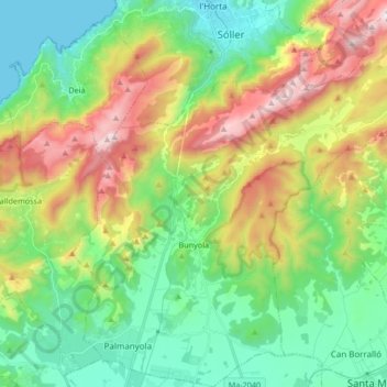
Name: Topografische Karte Bunyola, Höhe, Relief.
Ort: Bunyola, Serra de Tramuntana, Balearic Islands, Spain (39.64879 2.64585 39.77750 2.80188)
Durchschnittliche Höhe: 374 m
Minimale Höhe: 0 m
Maximale Höhe: 1.094 m
Spenden
Andere topografische Karten
Klicken Sie auf eine Karte, um ihre Topografie, ihre Höhe und ihr Relief anzuzeigen.
Serra de Tramuntana
Spain > Balearic Islands > Serra de Tramuntana
The climate in the Tramuntana Range is significantly wetter than the rest of the island, recording as much as 1507 mm (59.3 inches) of precipitation per year, in comparison with some other parts of the island where annual rainfall is less than 400mm (15 inch). It is also cooler due to the altitude, and a few…
Durchschnittliche Höhe: 175 m
Spenden
Mirador d'es Colomer
Spain > Balearic Islands > Serra de Tramuntana > Port de Pollença
Durchschnittliche Höhe: 79 m
Serra de Tramuntana
Spain > Balearic Islands > Serra de Tramuntana
The climate in the Tramuntana Range is significantly wetter than the rest of the island, recording as much as 1507 mm (59.3 inches) of precipitation per year, in comparison with some other parts of the island where annual rainfall is less than 400mm (15 inch). It is also cooler due to the altitude, and a few…
Durchschnittliche Höhe: 175 m
Spenden
Pla dels Egües
Spain > Balearic Islands > Serra de Tramuntana > Pollença
Durchschnittliche Höhe: 248 m
Cova de ses Bruixes
Spain > Balearic Islands > Serra de Tramuntana > Pollença
Durchschnittliche Höhe: 143 m
Serra de Tramuntana
Spain > Balearic Islands > Serra de Tramuntana
The climate in the Tramuntana Range is significantly wetter than the rest of the island, recording as much as 1507 mm (59.3 inches) of precipitation per year, in comparison with some other parts of the island where annual rainfall is less than 400mm (15 inch). It is also cooler due to the altitude, and a few…
Durchschnittliche Höhe: 175 m
Spenden
Puig Major
Spain > Balearic Islands > Serra de Tramuntana > Escorca
Puig Major is the highest peak on the Spanish island of Majorca. With an elevation of 1,436 m (4,711 ft) above sea level. It is situated in the Serra de Tramuntana mountains. As the mountain is located in a military zone, the neighbouring peak Puig de Massanella (1,364 m) is considered the highest accessible…
Durchschnittliche Höhe: 949 m
Spenden