
Spenden
Topografische Karte Anápolis
Klicken Sie auf die Karte, um die Höhe anzuzeigen.
Spenden
Anápolis
Anápolis is located in Center-Western Brazil. It is located in a plateau, called Central Plateau, at an elevation of 1,017 metres (3,337 ft). The area is 918.3 square kilometres (354.6 sq mi), and the limiting municipalities are Abadiânia, Campo Limpo de Goiás, Gameleira de Goiás, Goianápolis, Leopoldo de Bulhões, Nerópolis, Pirenópolis, Silvânia and Terezópolis de Goiás. Anápolis is also the center of the Anápolis Microregion, and belongs to the Goiás Center mesoregion.
Spenden
Über diese Karte
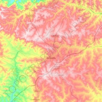
Name: Topografische Karte Anápolis, Höhe, Relief.
Durchschnittliche Höhe: 984 m
Minimale Höhe: 722 m
Maximale Höhe: 1.153 m
Spenden
Andere topografische Karten
Klicken Sie auf eine Karte, um ihre Topografie, ihre Höhe und ihr Relief anzuzeigen.
Spenden
Rosa
Brazil > Goiás > Região Integrada de Desenvolvimento do Distrito Federal e Entorno > Pirenópolis
Durchschnittliche Höhe: 780 m
Bom Jesus
Brazil > Goiás > Região Integrada de Desenvolvimento do Distrito Federal e Entorno > Pirenópolis
Durchschnittliche Höhe: 760 m
Spenden
Rio Arraial Velho
Brazil > Goiás > Região Integrada de Desenvolvimento do Distrito Federal e Entorno > Água Fria de Goiás
Durchschnittliche Höhe: 847 m
Paiol Velho
Brazil > Goiás > Região Integrada de Desenvolvimento do Distrito Federal e Entorno > Pirenópolis
Durchschnittliche Höhe: 730 m