
Spenden
Topografische Karte San Jose Sico
Klicken Sie auf die Karte, um die Höhe anzuzeigen.
Spenden
San Jose Sico
The city is the center of the radio listening market in Batangas, and is served by local radio stations, as well as some radio stations from Lipa and other parts of the Mega Manila area. The Roman Catholic Archdiocese of Lipa, through the Radyo Bayanihan System, hosts two local radio stations: ALFM 95.9 Radyo Totoo (DWAL), a religion, news, talk, and music-oriented station, and 99.1 Spirit FM (DWAM), a religion and music-oriented station. Other radio stations include 91.9 Air1 Radio Southern Tagalog (DWCH), an adult contemporary-oriented station, 99.9 GV FM (DZGV), a contemporary hit radio station, and 104.7 Brigada News FM (DWEY), an FM news radio station. Batangas State University hosts a college radio station, 107.3 BatStateU FM (DWPB-FM). Signals from other stations in Metro Manila are not clearly received because of the local topography.
Spenden
Über diese Karte
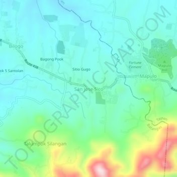
Name: Topografische Karte San Jose Sico, Höhe, Relief.
Ort: San Jose Sico, Batangas, Calabarzon, Philippines (13.71852 121.15248 13.75852 121.19248)
Durchschnittliche Höhe: 207 m
Minimale Höhe: 115 m
Maximale Höhe: 504 m
Spenden
Andere topografische Karten
Klicken Sie auf eine Karte, um ihre Topografie, ihre Höhe und ihr Relief anzuzeigen.
Spenden
Soro-soro Ibaba RWSA
Philippines > Batangas > Batangas City > Sorosoro Ibaba
Durchschnittliche Höhe: 113 m
Spenden
Spenden
Spenden
Spenden
Spenden
Spenden
Tabangao Aplaya
Philippines > Batangas > Batangas City > Tabangao Hilltop
Durchschnittliche Höhe: 37 m
Tabangao Aplaya
Philippines > Batangas > Batangas City > Tabangao Hilltop
Durchschnittliche Höhe: 37 m
Spenden
Spenden