
Topografische Karte Underwood
Interaktive Karte
Klicken Sie auf die Karte, um die Höhe anzuzeigen.
Über diese Karte
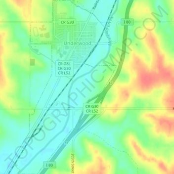
Name: Topografische Karte Underwood, Höhe, Relief.
Ort: Underwood, Pottawattamie County, Iowa, United States (41.36528 -95.69440 41.39443 -95.67008)
Durchschnittliche Höhe: 339 m
Minimale Höhe: 316 m
Maximale Höhe: 372 m
Andere topografische Karten
Klicken Sie auf eine Karte, um ihre Topografie, ihre Höhe und ihr Relief anzuzeigen.
Carson
United States > Iowa > Pottawattamie County
Carson, Pottawattamie County, Iowa, 51525, United States
Durchschnittliche Höhe: 341 m
Hitchcock Nature Center
United States > Iowa > Pottawattamie County
Hitchcock Nature Center, Pottawattamie County, Iowa, United States
Durchschnittliche Höhe: 338 m
Avoca
United States > Iowa > Pottawattamie County > Avoca
Avoca, Pottawattamie County, Iowa, 51521, United States
Durchschnittliche Höhe: 353 m