
Topografische Karte Madison County
Interaktive Karte
Klicken Sie auf die Karte, um die Höhe anzuzeigen.
Über diese Karte
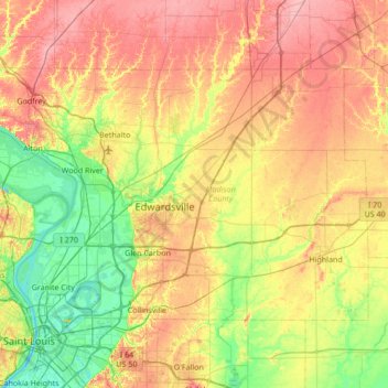
Name: Topografische Karte Madison County, Höhe, Relief.
Ort: Madison County, Illinois, USA (38.65590 -90.27581 39.00022 -89.59673)
Durchschnittliche Höhe: 161 m
Minimale Höhe: 119 m
Maximale Höhe: 212 m
Andere topografische Karten
Klicken Sie auf eine Karte, um ihre Topografie, ihre Höhe und ihr Relief anzuzeigen.
Fairview Heights
USA > Illinois > Fairview Heights
Fairview Heights, Saint Clair County, Illinois, 62208, USA
Durchschnittliche Höhe: 173 m
Park Ridge
USA > Illinois > Park Ridge
Park Ridge, Cook County, Illinois, USA
Durchschnittliche Höhe: 198 m
Hidden Lake
USA > Illinois > Hidden Lake
Hidden Lake, Cook County, Illinois, 60074, USA
Durchschnittliche Höhe: 225 m
Lake Marian
USA > Illinois > Carpentersville
Lake Marian, Carpentersville, Kane County, Illinois, 60110, USA
Durchschnittliche Höhe: 246 m
Montague Island
Montague Island, Rockford, Winnebago County, Illinois, 61104, USA
Durchschnittliche Höhe: 254 m
Mount Sumner
Mount Sumner, Jo Daviess County, Illinois, 61001, USA
Durchschnittliche Höhe: 294 m
Lake Carina
Lake Carina, Milwaukee Avenue, Gurnee, Lake County, Illinois, 60031:60085, USA
Durchschnittliche Höhe: 213 m
Lake Catherine
USA > Illinois > Lake Catherine
Lake Catherine, Lake County, Illinois, 60002, USA
Durchschnittliche Höhe: 229 m
Mount Carmel
USA > Illinois > Mount Carmel
Mount Carmel, Wabash County, Illinois, USA
Durchschnittliche Höhe: 128 m