
Topografische Karte Kechnec
Interaktive Karte
Klicken Sie auf die Karte, um die Höhe anzuzeigen.
Über diese Karte
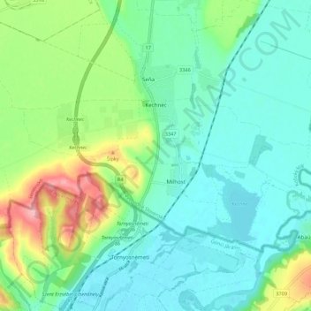
Name: Topografische Karte Kechnec, Höhe, Relief.
Durchschnittliche Höhe: 188 m
Minimale Höhe: 154 m
Maximale Höhe: 281 m
The village lies at an altitude of 180 metres and covers an area of 10.211 km2. The municipality is part of the administrative units Košice-okolie District and Košice Region. It has a population of about 1080 people.
Andere topografische Karten
Klicken Sie auf eine Karte, um ihre Topografie, ihre Höhe und ihr Relief anzuzeigen.
Čečejovce
Slovakia > Region of Košice > District of Košice - okolie
Čečejovce, District of Košice - okolie, Region of Košice, Eastern Slovakia, 044 71, Slovakia
Durchschnittliche Höhe: 217 m