
Topografische Karte Rodhuish
Klicken Sie auf die Karte, um die Höhe anzuzeigen.
Über diese Karte
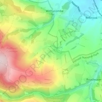
Name: Topografische Karte Rodhuish, Höhe, Relief.
Durchschnittliche Höhe: 157 m
Minimale Höhe: 18 m
Maximale Höhe: 372 m
Andere topografische Karten
Klicken Sie auf eine Karte, um ihre Topografie, ihre Höhe und ihr Relief anzuzeigen.
Quantock Hills National Landscape
United Kingdom > England > Somerset > Over Stowey
Durchschnittliche Höhe: 116 m
Mendip Hills National Landscape
United Kingdom > England > Somerset > Priddy
Durchschnittliche Höhe: 107 m
Mells Park
United Kingdom > England > Somerset > Vobster
The architect Edwin Lutyens had known the Horners, and Mells Park, since 1896. In 1918 he unsuccessfully tried to persuade the Horners to rebuild Park House. However, Reginald McKenna, the chairman of Midland Bank, and formerly Home Secretary and Chancellor of the Exchequer under Asquith, was married to Pamela…
Durchschnittliche Höhe: 134 m
Priddy
United Kingdom > England > Somerset
The village lies in a small hollow near the summit of the Mendip range of hills, at an elevation of nearly 1,000 feet (300 m) above sea-level, and has evidence of occupation since neolithic times. There are remains of lead mining activities and caves in the limestone beneath the village.
Durchschnittliche Höhe: 206 m
Yeovilton
United Kingdom > England > Somerset > South Somerset > Podimore
Durchschnittliche Höhe: 20 m
Castle Cary
United Kingdom > England > Somerset > Castle Cary > Galhampton
Durchschnittliche Höhe: 68 m
Muchelney
United Kingdom > England > Somerset
Muchelney (/ˈmʌtʃəlni/) is a clustered village and civil parish in Somerset, England, extending for 3 kilometres (1.9 mi) from the south bank of the River Parrett and that has a clustered centre. This is 1 mile (1.6 km) south of Huish and Langport and 4 miles (6.4 km) south west of Somerton in the South…
Durchschnittliche Höhe: 9 m