
Topografische Karte Mount Hopkins
Interaktive Karte
Klicken Sie auf die Karte, um die Höhe anzuzeigen.
Über diese Karte
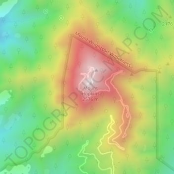
Name: Topografische Karte Mount Hopkins, Höhe, Relief.
Ort: Mount Hopkins, Santa Cruz County, Arizona, United States (31.68837 -110.88541 31.68847 -110.88531)
Durchschnittliche Höhe: 2.132 m
Minimale Höhe: 1.753 m
Maximale Höhe: 2.597 m
Andere topografische Karten
Klicken Sie auf eine Karte, um ihre Topografie, ihre Höhe und ihr Relief anzuzeigen.
Elgin
United States > Arizona > Santa Cruz County
Elgin, Santa Cruz County, Arizona, United States
Durchschnittliche Höhe: 1.484 m
Patagonia Lake
United States > Arizona > Santa Cruz County
Patagonia Lake, Santa Cruz County, Arizona, United States
Durchschnittliche Höhe: 1.188 m