
Topografische Karte Walla Walla
Interaktive Karte
Klicken Sie auf die Karte, um die Höhe anzuzeigen.
Über diese Karte
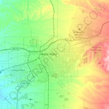
Name: Topografische Karte Walla Walla, Höhe, Relief.
Durchschnittliche Höhe: 297 m
Minimale Höhe: 209 m
Maximale Höhe: 417 m
Andere topografische Karten
Klicken Sie auf eine Karte, um ihre Topografie, ihre Höhe und ihr Relief anzuzeigen.
Ice Harbor Dam
United States > Washington > Walla Walla County
Ice Harbor Dam, Walla Walla County, Washington, United States
Durchschnittliche Höhe: 149 m
Burbank
United States > Washington > Walla Walla County
Burbank, Walla Walla County, Washington, 99323, United States
Durchschnittliche Höhe: 115 m
Waitsburg
United States > Washington > Walla Walla County
Waitsburg, Walla Walla County, Washington, United States
Durchschnittliche Höhe: 414 m
Buroker
United States > Washington > Walla Walla County
Buroker, Walla Walla County, Washington, United States
Durchschnittliche Höhe: 426 m
Wallula
United States > Washington > Walla Walla County
Wallula, Walla Walla County, Washington, United States
Durchschnittliche Höhe: 119 m
Dixie
United States > Washington > Walla Walla County > Dixie
Dixie, Walla Walla County, Washington, 99329, United States
Durchschnittliche Höhe: 537 m
Whitman Mission National Historic Site
United States > Washington > Walla Walla County
Whitman Mission National Historic Site, Walla Walla County, Washington, United States
Durchschnittliche Höhe: 196 m
College Place
United States > Washington > Walla Walla County
College Place, Walla Walla County, Washington, 99324, United States
Durchschnittliche Höhe: 244 m