
Spenden
Topografische Karte Daisy Lake
Klicken Sie auf die Karte, um die Höhe anzuzeigen.
Spenden
Über diese Karte
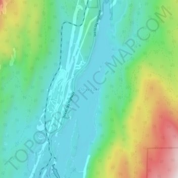
Name: Topografische Karte Daisy Lake, Höhe, Relief.
Durchschnittliche Höhe: 621 m
Minimale Höhe: 352 m
Maximale Höhe: 1.442 m
Spenden
Andere topografische Karten
Klicken Sie auf eine Karte, um ihre Topografie, ihre Höhe und ihr Relief anzuzeigen.
The Copilot
Canada > British Columbia > Squamish-Lillooet Regional District > Area D (Elaho/Garibaldi)
Durchschnittliche Höhe: 1.468 m
Mount Price
Canada > British Columbia > Squamish-Lillooet Regional District > Area D (Elaho/Garibaldi)
Mount Price is a small stratovolcano in the Garibaldi Ranges of the Pacific Ranges in southwestern British Columbia, Canada. It is located 10 km (6.2 mi) southeast of the abandoned settlement of Garibaldi above the eastern flank of the Cheakamus River valley. With a summit elevation of 2,049 m (6,722 ft), it…
Durchschnittliche Höhe: 1.672 m