
Topografische Karte Maghery
Interaktive Karte
Klicken Sie auf die Karte, um die Höhe anzuzeigen.
Über diese Karte
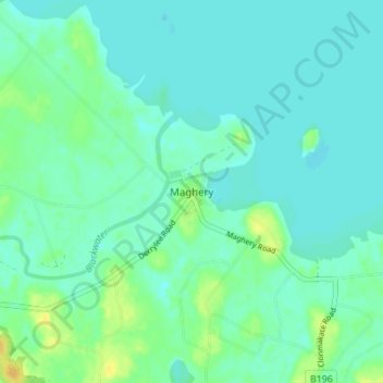
Name: Topografische Karte Maghery, Höhe, Relief.
Durchschnittliche Höhe: 14 m
Minimale Höhe: 8 m
Maximale Höhe: 31 m
Andere topografische Karten
Klicken Sie auf eine Karte, um ihre Topografie, ihre Höhe und ihr Relief anzuzeigen.
Portadown
United Kingdom > Northern Ireland > County Armagh
Portadown, County Armagh, Ulster, Northern Ireland, BT62 1BF, United Kingdom
Durchschnittliche Höhe: 28 m
Armagh
United Kingdom > Northern Ireland > County Armagh > Milford
Armagh, Milford, County Armagh, Ulster, Northern Ireland, United Kingdom
Durchschnittliche Höhe: 100 m
Seafin
United Kingdom > Northern Ireland > County Armagh
Seafin, County Armagh, Ulster, Northern Ireland, United Kingdom
Durchschnittliche Höhe: 161 m
Newtownhamilton
United Kingdom > Northern Ireland > County Armagh
Newtownhamilton, County Armagh, Ulster, Northern Ireland, BT35 0PB, United Kingdom
Durchschnittliche Höhe: 222 m
Hamiltons Bawn
United Kingdom > Northern Ireland > County Armagh
Hamiltons Bawn, County Armagh, Ulster, Northern Ireland, BT61 9SA, United Kingdom
Durchschnittliche Höhe: 101 m
Navan Fort
United Kingdom > Northern Ireland > County Armagh > Armagh
Navan Fort, Navan Fort Road, Armagh, County Armagh, Northern Ireland, B1604BD, United Kingdom
Durchschnittliche Höhe: 54 m
Meigh
United Kingdom > Northern Ireland > County Armagh > Meigh
Meigh, County Armagh, Northern Ireland, BT35 8GN, United Kingdom
Durchschnittliche Höhe: 139 m
Jonesborough
United Kingdom > Northern Ireland > County Armagh > Jonesborough
Jonesborough, County Armagh, Northern Ireland, BT35 8HR, United Kingdom
Durchschnittliche Höhe: 130 m