
Topografische Karte Kai Kung Shan
Interaktive Karte
Klicken Sie auf die Karte, um die Höhe anzuzeigen.
Über diese Karte
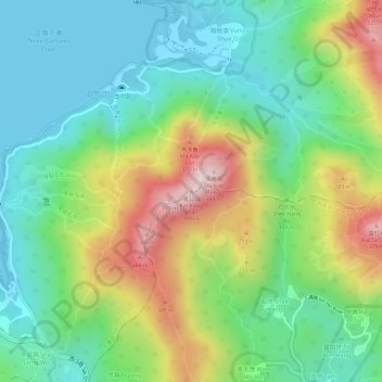
Name: Topografische Karte Kai Kung Shan, Höhe, Relief.
Durchschnittliche Höhe: 135 m
Minimale Höhe: -1 m
Maximale Höhe: 366 m
Andere topografische Karten
Klicken Sie auf eine Karte, um ihre Topografie, ihre Höhe und ihr Relief anzuzeigen.
Ting Kok
China > Hong Kong > Tai Po District > Ting Kok Village
Ting Kok, Plover Cove, Ting Kok Village, Tai Po District, New Territories, Hong Kong, China
Durchschnittliche Höhe: 121 m
Pyramid Hill
China > Hong Kong > Tai Po District
Pyramid Hill, Tai Po District, New Territories, Hong Kong, China
Durchschnittliche Höhe: 284 m
Tai Po
China > Hong Kong > Tai Po District
Tai Po, Tai Po District, New Territories, Hong Kong, China
Durchschnittliche Höhe: 155 m