Geolokalisieren
👉 Easily get elevation data in JSON, GeoTIFF and KML formats using Elevation API
Vielen Dank für die Unterstützung dieser Website ❤️
Spenden

Topografische Karte Wotton

Klicken Sie auf die Karte, um die Höhe anzuzeigen.

👉 Easily get elevation data in JSON, GeoTIFF and KML formats using Elevation API
Vielen Dank für die Unterstützung dieser Website ❤️
Spenden

Über diese Karte

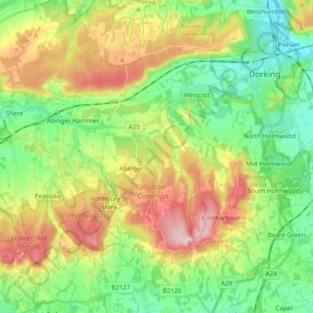
Name: Topografische Karte Wotton, Höhe, Relief.

Ort: Wotton, Mole Valley, Surrey, England, United Kingdom (51.15232 -0.41096 51.25701 -0.33569)

Durchschnittliche Höhe: 135 m

Minimale Höhe: 39 m

Maximale Höhe: 290 m

👉 Easily get elevation data in JSON, GeoTIFF and KML formats using Elevation API
Vielen Dank für die Unterstützung dieser Website ❤️
Spenden

Andere topografische Karten

Klicken Sie auf eine Karte, um ihre Topografie, ihre Höhe und ihr Relief anzuzeigen.

Box Hill

United Kingdom > England > Surrey > Mole Valley > Pixham

The 15.8 km (9.8 mi) Box Hill Olympic circuit is generally cycled in an anticlockwise direction and begins to the south of the village of Mickleham with an ascent of the hill via the Zig Zag Road. From the National Trust Visitor Centre, the route turns eastwards, running along the escarpment and through the…

Durchschnittliche Höhe: 105 m

Ashtead

United Kingdom > England > Surrey > Mole Valley

Durchschnittliche Höhe: 75 m

Clark's Green

United Kingdom > England > Surrey > Mole Valley > Capel

Durchschnittliche Höhe: 85 m

Broadmoor

United Kingdom > England > Surrey > Mole Valley

Durchschnittliche Höhe: 175 m

Vielen Dank für die Unterstützung dieser Website ❤️
Spenden

Westhumble

United Kingdom > England > Surrey > Mole Valley

Durchschnittliche Höhe: 97 m

Leatherhead

United Kingdom > England > Surrey > Mole Valley

Durchschnittliche Höhe: 81 m

Westhumble

United Kingdom > England > Surrey > Mole Valley

Durchschnittliche Höhe: 97 m

Abinger Bottom

United Kingdom > England > Surrey > Mole Valley > Abinger

Durchschnittliche Höhe: 196 m

Vielen Dank für die Unterstützung dieser Website ❤️
Spenden

Vale Farm

United Kingdom > England > Surrey > Mole Valley

Durchschnittliche Höhe: 136 m

Strood Green

United Kingdom > England > Surrey > Mole Valley > Brockham

Durchschnittliche Höhe: 60 m

Dorking

United Kingdom > England > Surrey > Mole Valley

Durchschnittliche Höhe: 107 m

Abinger Roughs

United Kingdom > England > Surrey > Mole Valley > Abinger Hammer

Durchschnittliche Höhe: 141 m

Vielen Dank für die Unterstützung dieser Website ❤️
Spenden

Headley Heath

United Kingdom > England > Surrey > Mole Valley > Headley

Durchschnittliche Höhe: 163 m

Hookwood

United Kingdom > England > Surrey > Mole Valley

Durchschnittliche Höhe: 60 m

Leith Hill

United Kingdom > England > Surrey > Mole Valley

Durchschnittliche Höhe: 196 m

Great Bookham

United Kingdom > England > Surrey > Mole Valley

Durchschnittliche Höhe: 80 m

Vielen Dank für die Unterstützung dieser Website ❤️
Spenden

Box Hill Village

United Kingdom > England > Surrey > Mole Valley

Durchschnittliche Höhe: 125 m

Westcott

United Kingdom > England > Surrey > Mole Valley

Durchschnittliche Höhe: 116 m

Okewood Hill

United Kingdom > England > Surrey > Mole Valley

Durchschnittliche Höhe: 67 m

Abinger Hammer

United Kingdom > England > Surrey > Mole Valley

Durchschnittliche Höhe: 139 m

Vielen Dank für die Unterstützung dieser Website ❤️
Spenden

Beare Green

United Kingdom > England > Surrey > Mole Valley

Durchschnittliche Höhe: 107 m

Capel

United Kingdom > England > Surrey > Mole Valley

Durchschnittliche Höhe: 91 m

South Holmwood

United Kingdom > England > Surrey > Mole Valley > South Holmwood

Durchschnittliche Höhe: 116 m

Lodge Hill

United Kingdom > England > Surrey > Mole Valley

Durchschnittliche Höhe: 110 m

Vielen Dank für die Unterstützung dieser Website ❤️
Spenden

Givons Grove

United Kingdom > England > Surrey > Mole Valley

Durchschnittliche Höhe: 87 m

Box Hill

United Kingdom > England > Surrey > Mole Valley > Pixham

The 15.8 km (9.8 mi) Box Hill Olympic circuit is generally cycled in an anticlockwise direction and begins to the south of the village of Mickleham with an ascent of the hill via the Zig Zag Road. From the National Trust Visitor Centre, the route turns eastwards, running along the escarpment and through the…

Durchschnittliche Höhe: 105 m

Dorking

United Kingdom > England > Surrey > Mole Valley

Durchschnittliche Höhe: 107 m

Dorking

United Kingdom > England > Surrey > Mole Valley

Durchschnittliche Höhe: 107 m

Vielen Dank für die Unterstützung dieser Website ❤️
Spenden

Leatherhead

United Kingdom > England > Surrey > Mole Valley

Durchschnittliche Höhe: 81 m

Ashtead

United Kingdom > England > Surrey > Mole Valley

Durchschnittliche Höhe: 75 m

Dorking

United Kingdom > England > Surrey > Mole Valley

Durchschnittliche Höhe: 107 m