Geolokalisieren
👉 Easily get elevation data in JSON, GeoTIFF and KML formats using Elevation API
Vielen Dank für die Unterstützung dieser Website ❤️
Spenden

Topografische Karte Ecclesfield

Klicken Sie auf die Karte, um die Höhe anzuzeigen.

👉 Easily get elevation data in JSON, GeoTIFF and KML formats using Elevation API
Vielen Dank für die Unterstützung dieser Website ❤️
Spenden

Ecclesfield

Ecclesfield lies in the north of Sheffield, about 4 miles (7 km) north of the city centre. The suburb of Ecclesfield is in the south-east of the civil parish with the suburbs Chapeltown and High Green to the north, and Grenoside to the west. Its altitude is 60 metres (200 ft) to 120 metres (390 ft) above mean sea level. At the 2001 census the civil parish—which also includes the Sheffield suburbs of Chapeltown, Grenoside, High Green, and formerly Thorpe Hesley (now a suburb of Rotherham)—had a population of 31,609.

Wikipedia (CC-BY-SA 3.0)

👉 Easily get elevation data in JSON, GeoTIFF and KML formats using Elevation API
Vielen Dank für die Unterstützung dieser Website ❤️
Spenden

Über diese Karte

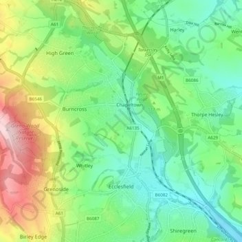
Name: Topografische Karte Ecclesfield, Höhe, Relief.

Ort: Ecclesfield, Whitley, Sheffield, South Yorkshire, England, United Kingdom (53.42945 -1.52092 53.48662 -1.43335)

Durchschnittliche Höhe: 128 m

Minimale Höhe: 42 m

Maximale Höhe: 301 m

👉 Easily get elevation data in JSON, GeoTIFF and KML formats using Elevation API
Vielen Dank für die Unterstützung dieser Website ❤️
Spenden

Andere topografische Karten

Klicken Sie auf eine Karte, um ihre Topografie, ihre Höhe und ihr Relief anzuzeigen.

Grenoside

United Kingdom > England > Sheffield > Whitley

Durchschnittliche Höhe: 121 m

Ecclesfield

United Kingdom > England > Sheffield > Whitley

Durchschnittliche Höhe: 217 m