
Topografische Karte Épernay
Interaktive Karte
Klicken Sie auf die Karte, um die Höhe anzuzeigen.
Über diese Karte
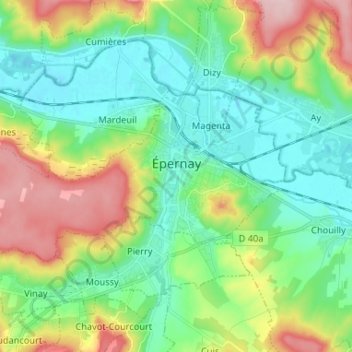
Name: Topografische Karte Épernay, Höhe, Relief.
Ort: Épernay, Marne, Grand Est, France métropolitaine, 51200, France (49.01798 3.86277 49.06028 3.99365)
Durchschnittliche Höhe: 129 m
Minimale Höhe: 63 m
Maximale Höhe: 269 m
La vallée du Cubry a perdu son flanc est sous l'effet de l'érosion. Il n'en subsiste que le Mont Bernon, qui culmine à 206 mètres d'altitude. La ville marque l'entrée de la Marne dans le plateau tertiaire parisien, séparé par la rivière entre la Montagne de Reims au nord et la Brie champenoise au sud. La partie occidentale de la commune est formée par un plateau s'élevant au-delà de 220 mètres. Alors que l'altitude en centre-ville est de 75 mètres, le plateau atteint 253 mètres.
Andere topografische Karten
Klicken Sie auf eine Karte, um ihre Topografie, ihre Höhe und ihr Relief anzuzeigen.
Saint-Remy-sur-Bussy
Saint-Remy-sur-Bussy, Châlons-en-Champagne, Marne, Grand Est, France métropolitaine, 51600, France
Durchschnittliche Höhe: 162 m
Chemin de la Chaussée
France > Grand Est > Marne > Saint-Jean-sur-Moivre
Chemin de la Chaussée, Saint-Jean-sur-Moivre, Châlons-en-Champagne, Marne, Grand Est, France métropolitaine, 51240, France
Durchschnittliche Höhe: 131 m
Mormont
France > Grand Est > Marne > Lisse-en-Champagne
Mormont, Lisse-en-Champagne, Vitry-le-François, Marne, Grand Est, France métropolitaine, 51300, France
Durchschnittliche Höhe: 177 m
Mont Herme
France > Grand Est > Marne > Saint-Brice-Courcelles
Mont Herme, Saint-Brice-Courcelles, Reims, Marne, Grand Est, France métropolitaine, 51370, France
Durchschnittliche Höhe: 80 m
Charleville
France > Grand Est > Marne > Charleville
Charleville, Épernay, Marne, Grand Est, France métropolitaine, 51120, France
Durchschnittliche Höhe: 203 m
Saint-Saturnin
Saint-Saturnin, Épernay, Marne, Grand Est, France métropolitaine, 51260, France
Durchschnittliche Höhe: 84 m
Vitry-le-François
France > Grand Est > Marne > Vitry-le-François
Vitry-le-François, Marne, Grand Est, France métropolitaine, 51300, France
Durchschnittliche Höhe: 101 m
Saint-Chéron
France > Grand Est > Marne > Saint-Chéron
Saint-Chéron, Vitry-le-François, Marne, Grand Est, France métropolitaine, 51290, France
Durchschnittliche Höhe: 140 m
Saint-Gilles
Saint-Gilles, Reims, Marne, Grand Est, France métropolitaine, 51170, France
Durchschnittliche Höhe: 118 m
Hautvillers
France > Grand Est > Marne > Hautvillers
Hautvillers, Épernay, Marne, Grand Est, France métropolitaine, 51160, France
Durchschnittliche Höhe: 178 m
Montmort-Lucy
Montmort-Lucy, Épernay, Marne, Grand Est, France métropolitaine, 51270, France
Durchschnittliche Höhe: 220 m
Châtillon-sur-Broué
Châtillon-sur-Broué, Vitry-le-François, Marne, Grand Est, France métropolitaine, 51290, France
Durchschnittliche Höhe: 128 m