
Topografische Karte Rock
Interaktive Karte
Klicken Sie auf die Karte, um die Höhe anzuzeigen.
Über diese Karte
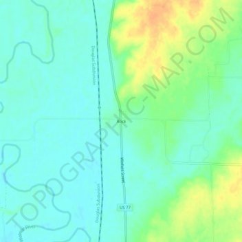
Name: Topografische Karte Rock, Höhe, Relief.
Ort: Rock, Cowley County, Kansas, United States (37.42030 -97.02643 37.46030 -96.98643)
Durchschnittliche Höhe: 362 m
Minimale Höhe: 350 m
Maximale Höhe: 386 m
Andere topografische Karten
Klicken Sie auf eine Karte, um ihre Topografie, ihre Höhe und ihr Relief anzuzeigen.
Grouse Creek
United States > Kansas > Cowley County
Grouse Creek, Cowley County, Kansas, United States
Durchschnittliche Höhe: 381 m
Dexter
United States > Kansas > Cowley County
Dexter, Cowley County, Kansas, United States
Durchschnittliche Höhe: 374 m
Burden
United States > Kansas > Cowley County
Burden, Cowley County, Kansas, United States
Durchschnittliche Höhe: 421 m
Atlanta
United States > Kansas > Cowley County
Atlanta, Cowley County, Kansas, United States
Durchschnittliche Höhe: 432 m
Cambridge
United States > Kansas > Cowley County
Cambridge, Cowley County, Kansas, United States
Durchschnittliche Höhe: 397 m
Parkerfield
United States > Kansas > Cowley County
Parkerfield, Cowley County, Kansas, United States
Durchschnittliche Höhe: 351 m
Maple City
United States > Kansas > Cowley County > Maple City
Maple City, Cowley County, Kansas, 67102, United States
Durchschnittliche Höhe: 402 m
Arkansas City
United States > Kansas > Cowley County > Arkansas City > Arkansas City
Arkansas City, Cowley County, Kansas, 67005, United States
Durchschnittliche Höhe: 339 m
Udall
United States > Kansas > Cowley County
Udall, Cowley County, Kansas, United States
Durchschnittliche Höhe: 384 m
Winfield
United States > Kansas > Cowley County
Winfield, Cowley County, Kansas, 67156, United States
Durchschnittliche Höhe: 367 m
Arkansas City
United States > Kansas > Cowley County
Arkansas City, Cowley County, Kansas, 67005, United States
Durchschnittliche Höhe: 345 m