
Topografische Karte Cheekha Dar
Interaktive Karte
Klicken Sie auf die Karte, um die Höhe anzuzeigen.
Cheekha Dar
It was climbed in November 2004 by English explorer Ginge Fullen, who recorded a GPS reading of 3,628 meters at the coordinates in the adjacent table. The location is consistent with SRTM and Russian topographic mapping, although these sources are more consistent with the CIA height.
Über diese Karte
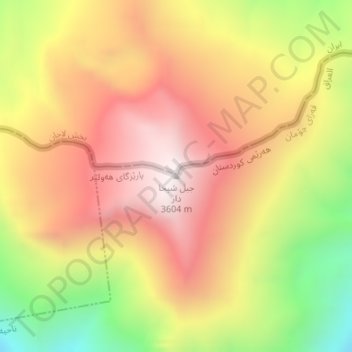
Name: Topografische Karte Cheekha Dar, Höhe, Relief.
Durchschnittliche Höhe: 3.165 m
Minimale Höhe: 2.587 m
Maximale Höhe: 3.602 m
Andere topografische Karten
Klicken Sie auf eine Karte, um ihre Topografie, ihre Höhe und ihr Relief anzuzeigen.