
Topografische Karte Ramagundam
Interaktive Karte
Klicken Sie auf die Karte, um die Höhe anzuzeigen.
Über diese Karte
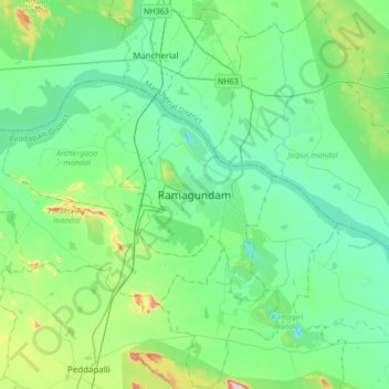
Name: Topografische Karte Ramagundam, Höhe, Relief.
Durchschnittliche Höhe: 174 m
Minimale Höhe: 90 m
Maximale Höhe: 514 m
Ramagundam is located at 18°45′50″N 79°28′30″E / 18.7638°N 79.4750°E / 18.7638; 79.4750. It has an average elevation of 179 meters (590 feet). It is about 225 kilometres (140 mi) northeast of the state capital, Hyderabad, 65 km from Karimnagar, 0 km from Ramagundam district headquarters and 0.1 km from Godavarikhani.