
Spenden
Topografische Karte Trindade
Klicken Sie auf die Karte, um die Höhe anzuzeigen.
Spenden
Über diese Karte
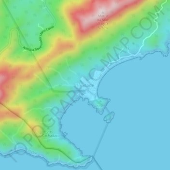
Name: Topografische Karte Trindade, Höhe, Relief.
Durchschnittliche Höhe: 126 m
Minimale Höhe: -1 m
Maximale Höhe: 547 m
Spenden
Andere topografische Karten
Klicken Sie auf eine Karte, um ihre Topografie, ihre Höhe und ihr Relief anzuzeigen.
Rio de Janeiro
Temperature also varies according to elevation, distance from the coast, and type of vegetation or land use. During the winter, cold fronts and dawn/morning sea breezes bring mild temperatures; cold fronts, the Intertropical Convergence Zone (in the form of winds from the Amazon Forest), the strongest…
Durchschnittliche Höhe: 43 m
Rio de Janeiro
Brazil > Rio de Janeiro > Região Metropolitana do Rio de Janeiro
Rio has a tropical wet and dry climate (Köppen: Aw, Trewartha: Awab borderline Awha), and is often characterized by long periods of heavy rain between December and March. The city experiences hot, humid summers, and warm, sunny winters. In inland areas of the city, temperatures above 40 °C (104 °F) are…
Durchschnittliche Höhe: 43 m
Spenden
Santa Teresa
Brazil > Rio de Janeiro > Rio de Janeiro
Around 1850 many people, fleeing the yellow fever epidemic in the city, flocked to the neighborhood. As it was at a higher altitude, Santa Teresa was less affected by the epidemic than the surrounding neighborhoods.
Durchschnittliche Höhe: 55 m
Rio de Janeiro
Brazil > Rio de Janeiro > Região Metropolitana do Rio de Janeiro
Temperature also varies according to elevation, distance from the coast, and type of vegetation or land use. During the winter, cold fronts and dawn/morning sea breezes bring mild temperatures; cold fronts, the Intertropical Convergence Zone (in the form of winds from the Amazon Forest), the strongest…
Durchschnittliche Höhe: 43 m
Rio de Janeiro
Temperature also varies according to elevation, distance from the coast, and type of vegetation or land use. During the winter, cold fronts and dawn/morning sea breezes bring mild temperatures; cold fronts, the Intertropical Convergence Zone (in the form of winds from the Amazon Forest), the strongest…
Durchschnittliche Höhe: 43 m
Spenden
São Francisco Xavier
Brazil > Rio de Janeiro > Região Metropolitana do Rio de Janeiro > Rio de Janeiro
Durchschnittliche Höhe: 35 m
Rio de Janeiro
Brazil > Rio de Janeiro > Região Metropolitana do Rio de Janeiro
Temperature also varies according to elevation, distance from the coast, and type of vegetation or land use. During the winter, cold fronts and dawn/morning sea breezes bring mild temperatures; cold fronts, the Intertropical Convergence Zone (in the form of winds from the Amazon Forest), the strongest…
Durchschnittliche Höhe: 43 m
Praça Heitor Bastos Tigre
Brazil > Rio de Janeiro > Região Metropolitana do Rio de Janeiro > Rio de Janeiro
Durchschnittliche Höhe: 7 m
Spenden
Vista Alegre
Brazil > Rio de Janeiro > Região Metropolitana do Rio de Janeiro > Rio de Janeiro
Durchschnittliche Höhe: 18 m
Santa Teresa
Brazil > Rio de Janeiro > Região Metropolitana do Rio de Janeiro > Rio de Janeiro
Around 1850 many people, fleeing the yellow fever epidemic in the city, flocked to the neighborhood. As it was at a higher altitude, Santa Teresa was less affected by the epidemic than the surrounding neighborhoods.
Durchschnittliche Höhe: 55 m
Spenden
Rio de Janeiro
Brazil > Rio de Janeiro > Região Metropolitana do Rio de Janeiro
Rio has a tropical wet and dry climate (Köppen: Aw, Trewartha: Awab), and is often characterized by long periods of heavy rain between December and March. The city experiences hot, humid summers, and warm, sunny winters. In inland areas of the city, temperatures above 40 °C (104 °F) are common during the…
Durchschnittliche Höhe: 43 m
Itaguaí
Brazil > Rio de Janeiro > Região Metropolitana do Rio de Janeiro
Durchschnittliche Höhe: 109 m
Spenden
Rio Bonito
Brazil > Rio de Janeiro > Região Metropolitana do Rio de Janeiro
Durchschnittliche Höhe: 147 m
Campos dos Goytacazes
Campos dos Goytacazes has an area of 4,032 km2 (1,557 sq mi), which makes it the largest municipality in the state by area, and its elevation is 14 m. Its name comes from the geographical characteristic of the region, very flat with fields (campos in Portuguese) and from the Goytacazes Indians, which inhabited…
Durchschnittliche Höhe: 61 m
Rio de Janeiro
Temperature also varies according to elevation, distance from the coast, and type of vegetation or land use. During the winter, cold fronts and dawn/morning sea breezes bring mild temperatures; cold fronts, the Intertropical Convergence Zone (in the form of winds from the Amazon Forest), the strongest…
Durchschnittliche Höhe: 43 m
Spenden
Alto da Boa Vista
Brazil > Rio de Janeiro > Região Metropolitana do Rio de Janeiro > Rio de Janeiro
Durchschnittliche Höhe: 245 m
Boa Esperança
Brazil > Rio de Janeiro > Região Metropolitana do Rio de Janeiro > Rio Bonito
Durchschnittliche Höhe: 102 m
Spenden
Copacabana Beach
Brazil > Rio de Janeiro > Região Metropolitana do Rio de Janeiro > Rio de Janeiro
Durchschnittliche Höhe: 38 m
Botafogo
Brazil > Rio de Janeiro > Região Metropolitana do Rio de Janeiro > Rio de Janeiro
Durchschnittliche Höhe: 52 m
Spenden
Itaguaí
Brazil > Rio de Janeiro > Região Metropolitana do Rio de Janeiro
Durchschnittliche Höhe: 154 m
Paracambi
Brazil > Rio de Janeiro > Região Metropolitana do Rio de Janeiro
Durchschnittliche Höhe: 249 m
Quinta da Boa Vista
Brazil > Rio de Janeiro > Região Metropolitana do Rio de Janeiro > Rio de Janeiro
Durchschnittliche Höhe: 19 m
Spenden
Cachoeiras de Macacu
Brazil > Rio de Janeiro > Região Metropolitana do Rio de Janeiro
Durchschnittliche Höhe: 423 m
Jacarezinho
Brazil > Rio de Janeiro > Região Metropolitana do Rio de Janeiro > Rio de Janeiro
Durchschnittliche Höhe: 18 m
Rocinha
Brazil > Rio de Janeiro > Região Metropolitana do Rio de Janeiro > Rio de Janeiro
Durchschnittliche Höhe: 161 m
Belford Roxo
Brazil > Rio de Janeiro > Região Metropolitana do Rio de Janeiro
In 1767, in a topographic map of the captaincy of Rio de Janeiro, made by Manuel Vieira Lion, appears clearly in this region the ingenuity of Brejo. Its first occupant was Christopher Mendes Leitão, in 1739.
Durchschnittliche Höhe: 31 m
Spenden
Copacabana
Brazil > Rio de Janeiro > Região Metropolitana do Rio de Janeiro > Rio de Janeiro
Durchschnittliche Höhe: 41 m
Vital Brazil
Brazil > Rio de Janeiro > Região Metropolitana do Rio de Janeiro > Niterói > Região Praias da Baía
Durchschnittliche Höhe: 41 m
Spenden
Copacabana
Brazil > Rio de Janeiro > Região Metropolitana do Rio de Janeiro > Rio de Janeiro
Durchschnittliche Höhe: 41 m
Petrópolis
Brazil > Rio de Janeiro > Região Metropolitana do Rio de Janeiro
Petrópolis has a tropical highland climate (Köppen climate classification: Cwa) caused by elevation with humid summers. The rainfall is approximately 1,383 mm (54.4 in) per annum.
Durchschnittliche Höhe: 832 m
Spenden
Méier
Brazil > Rio de Janeiro > Região Metropolitana do Rio de Janeiro > Rio de Janeiro
Durchschnittliche Höhe: 38 m
Bazílio
Brazil > Rio de Janeiro > Região Metropolitana do Rio de Janeiro > Rio Bonito
Durchschnittliche Höhe: 180 m
São Francisco
Brazil > Rio de Janeiro > Região Metropolitana do Rio de Janeiro > Niterói > Região Praias da Baía
Durchschnittliche Höhe: 83 m
Spenden
Spenden
Campo Grande
Brazil > Rio de Janeiro > Região Metropolitana do Rio de Janeiro > Rio de Janeiro
Durchschnittliche Höhe: 113 m
Spenden
Vasco da Gama
Brazil > Rio de Janeiro > Região Metropolitana do Rio de Janeiro > Rio de Janeiro
Durchschnittliche Höhe: 15 m
Vidigal
Brazil > Rio de Janeiro > Região Metropolitana do Rio de Janeiro > Rio de Janeiro
Durchschnittliche Höhe: 79 m
Spenden
Guapimirim
Brazil > Rio de Janeiro > Região Metropolitana do Rio de Janeiro
Durchschnittliche Höhe: 260 m
Região Norte
Brazil > Rio de Janeiro > Região Metropolitana do Rio de Janeiro > Niterói
Durchschnittliche Höhe: 54 m
Spenden
Lins de Vasconcelos
Brazil > Rio de Janeiro > Região Metropolitana do Rio de Janeiro > Rio de Janeiro
Durchschnittliche Höhe: 128 m
Queimados
Brazil > Rio de Janeiro > Região Metropolitana do Rio de Janeiro
Queimados (Portuguese pronunciation: [kejˈmadus]) is a municipality located in the Brazilian state of Rio de Janeiro. It is located at 22º42'58" south latitude and 43º33'19" west longitude, at an altitude of 29 meters. Its population was 151,335 (2020) and its area is 75 km2. The city is divided into 37…
Durchschnittliche Höhe: 61 m
Duque de Caxias
Brazil > Rio de Janeiro > Região Metropolitana do Rio de Janeiro
Durchschnittliche Höhe: 259 m
Botafogo
Brazil > Rio de Janeiro > Região Metropolitana do Rio de Janeiro > Rio de Janeiro
Durchschnittliche Höhe: 52 m
Spenden
Região Norte
Brazil > Rio de Janeiro > Região Metropolitana do Rio de Janeiro > Niterói
Durchschnittliche Höhe: 54 m
São Conrado
Brazil > Rio de Janeiro > Região Metropolitana do Rio de Janeiro > Rio de Janeiro
Durchschnittliche Höhe: 115 m
Bangu
Brazil > Rio de Janeiro > Região Metropolitana do Rio de Janeiro > Rio de Janeiro
Durchschnittliche Höhe: 119 m
Spenden
Nova Iguaçu
Brazil > Rio de Janeiro > Região Metropolitana do Rio de Janeiro
Durchschnittliche Höhe: 163 m
Rocha
Brazil > Rio de Janeiro > Região Metropolitana do Rio de Janeiro > Rio de Janeiro
Durchschnittliche Höhe: 35 m
Rio de Janeiro
Brazil > Rio de Janeiro > Região Metropolitana do Rio de Janeiro
Temperature also varies according to elevation, distance from the coast, and type of vegetation or land use. During the winter, cold fronts and dawn/morning sea breezes bring mild temperatures; cold fronts, the Intertropical Convergence Zone (in the form of winds from the Amazon Forest), the strongest…
Durchschnittliche Höhe: 43 m
Spenden
Paraíba do Sul
Located at 306 m altitude, Paraíba do Sul is located at latitude 22°09'43" south and longitude 43°17'34" west. It has an area of 582.21 square kilometres (224.79 sq mi).
Durchschnittliche Höhe: 512 m
Santo Elias
Brazil > Rio de Janeiro > Região Metropolitana do Rio de Janeiro
Durchschnittliche Höhe: 23 m
Rio de Janeiro
Brazil > Rio de Janeiro > Região Metropolitana do Rio de Janeiro
Temperature also varies according to elevation, distance from the coast, and type of vegetation or land use. During the winter, cold fronts and dawn/morning sea breezes bring mild temperatures; cold fronts, the Intertropical Convergence Zone (in the form of winds from the Amazon Forest), the strongest…
Durchschnittliche Höhe: 43 m
Engenho de Dentro
Brazil > Rio de Janeiro > Região Metropolitana do Rio de Janeiro > Rio de Janeiro
Durchschnittliche Höhe: 87 m
Spenden
Jacarezinho
Brazil > Rio de Janeiro > Região Metropolitana do Rio de Janeiro > Rio de Janeiro
Durchschnittliche Höhe: 18 m
Santa Teresa
Brazil > Rio de Janeiro > Região Metropolitana do Rio de Janeiro > Rio de Janeiro
Around 1850 many people, fleeing the yellow fever epidemic in the city, flocked to the neighborhood. As it was at a higher altitude, Santa Teresa was less affected by the epidemic than the surrounding neighborhoods.
Durchschnittliche Höhe: 55 m
Spenden
Icaraí
Brazil > Rio de Janeiro > Região Metropolitana do Rio de Janeiro > Niterói
Durchschnittliche Höhe: 28 m
Xerém
Brazil > Rio de Janeiro > Região Metropolitana do Rio de Janeiro > Duque de Caxias
Durchschnittliche Höhe: 322 m
Spenden
Inhomirim
Brazil > Rio de Janeiro > Região Metropolitana do Rio de Janeiro > Magé
Durchschnittliche Höhe: 139 m
Visconde
Brazil > Rio de Janeiro > Região Metropolitana do Rio de Janeiro > Itaboraí > Visconde de Itaboraí
Durchschnittliche Höhe: 9 m
Spenden
Campos dos Goytacazes
Campos dos Goytacazes has an area of 4,032 km2 (1,557 sq mi), which makes it the largest municipality in the state by area, and its elevation is 14 m. Its name comes from the geographical characteristic of the region, very flat with fields (campos in Portuguese) and from the Goytacazes Indians, which inhabited…
Durchschnittliche Höhe: 61 m
Spenden