
Topografische Karte Monumento Natural Teta de Niquitao - Guirigay
Interaktive Karte
Klicken Sie auf die Karte, um die Höhe anzuzeigen.
Über diese Karte
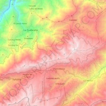
Name: Topografische Karte Monumento Natural Teta de Niquitao - Guirigay, Höhe, Relief.
Durchschnittliche Höhe: 2.696 m
Minimale Höhe: 757 m
Maximale Höhe: 3.966 m
Andere topografische Karten
Klicken Sie auf eine Karte, um ihre Topografie, ihre Höhe und ihr Relief anzuzeigen.
Municipio Rafael Rangel
Municipio Rafael Rangel, Trujillo, 3104, Venezuela
Durchschnittliche Höhe: 718 m
Municipio Pampanito
Municipio Pampanito, Trujillo, Venezuela
Durchschnittliche Höhe: 541 m
Municipio Escuque
Municipio Escuque, Trujillo, Venezuela
Durchschnittliche Höhe: 1.087 m
Municipio Boconó
Municipio Boconó, Trujillo, 3103, Venezuela
Durchschnittliche Höhe: 1.510 m
Municipio Carache
Municipio Carache, Trujillo, Venezuela
Durchschnittliche Höhe: 1.390 m
Sabana de Mendoza
Venezuela > Trujillo > Sabana de Mendoza
Sabana de Mendoza, Municipio Sucre, Trujillo, 3110, Venezuela
Durchschnittliche Höhe: 132 m
Municipio Andrés Bello
Municipio Andrés Bello, Trujillo, Venezuela
Durchschnittliche Höhe: 234 m
Municipio La Ceiba
Municipio La Ceiba, Trujillo, Venezuela
Durchschnittliche Höhe: 11 m
Municipio Candelaria
Municipio Candelaria, Trujillo, Venezuela
Durchschnittliche Höhe: 421 m
Campo Elías
Venezuela > Trujillo > Campo Elías
Campo Elías, Municipio Juan Vicente Campo Elias, Trujillo, Venezuela
Durchschnittliche Höhe: 1.156 m