
Spenden
Topografische Karte Anamã
Klicken Sie auf die Karte, um die Höhe anzuzeigen.
Spenden
Anamã
Limited to the north and west by the municipality of Anori; to the south with the municipality of Beruri; and to the east, with Manacapuru, municipality currently has 22 communities, whose main are: Arixi; Cabaça; New Brazil; Mato Rosso; Nossa Senhora de Nazaré and the indigenous communities of São José of Eware (tikunas), Bom Jesus, Nova Esperança and Santa Luzia (kokamas) on the fluvial island of the Chameleon. The climate is typically hot and humid equatorial, clearly visible in the dry and rainy seasons, in the high altitudes do not cause significant changes in the thermal averages. October is the month hot, with average temperatures of 33 °C (91,4 °F); June is usually the coldest month, has an average temperature of 24 °C (75,2 °F). The absolute maximum hardly exceeds 38 °C (100,4 °F), that in the warmer months (September, October and November). In the winter, the thermal sensation is mild, despite it is subject to the low temperatures with averages of 22 °C (71,6 °F) until 18 °C (64,4 °F). The months of November to March occurs 85% of the annual precipitation rainy.
Spenden
Über diese Karte
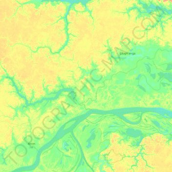
Name: Topografische Karte Anamã, Höhe, Relief.
Durchschnittliche Höhe: 29 m
Minimale Höhe: 7 m
Maximale Höhe: 78 m
Spenden
Andere topografische Karten
Klicken Sie auf eine Karte, um ihre Topografie, ihre Höhe und ihr Relief anzuzeigen.
Pico da Neblina
Brazil > Amazonas > Santa Isabel do Rio Negro
For 39 years, based on an uncontested measurement performed in 1965 by topographer José Ambrósio de Miranda Pombo, using a theodolite, the elevation of Pico da Neblina was thought to be 3,014 metres (9,888 ft), but a much more accurate measurement performed in 2004 with state-of-the-art GPS equipment by…
Durchschnittliche Höhe: 2.178 m
Amazon River
Brazil > Amazonas > Careiro da Várzea
During what many archaeologists called the formative stage, Amazonian societies were deeply involved in the emergence of South America's highland agrarian systems. The trade with Andean civilizations in the terrains of the headwaters in the Andes formed an essential contribution to the social and religious…
Durchschnittliche Höhe: 21 m
Spenden
Spenden
Amazon River
During what many archaeologists called the formative stage, Amazonian societies were deeply involved in the emergence of South America's highland agrarian systems. The trade with Andean civilizations in the terrains of the headwaters in the Andes formed an essential contribution to the social and religious…
Durchschnittliche Höhe: 11 m
Spenden
Amazon River
Brazil > Amazonas > Itacoatiara
During what many archaeologists called the formative stage, Amazonian societies were deeply involved in the emergence of South America's highland agrarian systems. The trade with Andean civilizations in the terrains of the headwaters in the Andes formed an essential contribution to the social and religious…
Durchschnittliche Höhe: 11 m
Spenden
Pico da Neblina
Brazil > Amazonas > Santa Isabel do Rio Negro
For 39 years, based on an uncontested measurement performed in 1965 by topographer José Ambrósio de Miranda Pombo, using a theodolite, the elevation of Pico da Neblina was thought to be 3,014 metres (9,888 ft), but a much more accurate measurement performed in 2004 with state-of-the-art GPS equipment by…
Durchschnittliche Höhe: 2.178 m
Spenden
Amazon River
Brazil > Amazonas > Careiro da Várzea
During what many archaeologists called the formative stage, Amazonian societies were deeply involved in the emergence of South America's highland agrarian systems. The trade with Andean civilizations in the terrains of the headwaters in the Andes formed an essential contribution to the social and religious…
Durchschnittliche Höhe: 21 m
Spenden
Espirito Santo
Brazil > Amazonas > Santa Isabel do Rio Negro > Santa Isabel do Rio Negro
Durchschnittliche Höhe: 39 m
Ilha de Curupira
Brazil > Amazonas > Santa Isabel do Rio Negro > Santa Isabel do Rio Negro
Durchschnittliche Höhe: 35 m
Spenden
Presidente Figueiredo
Brazil > Amazonas > Presidente Figueiredo > Presidente Figueiredo
Durchschnittliche Höhe: 111 m
Spenden
Spenden