
Topografische Karte Whitworth
Klicken Sie auf die Karte, um die Höhe anzuzeigen.
Über diese Karte
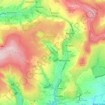
Name: Topografische Karte Whitworth, Höhe, Relief.
Durchschnittliche Höhe: 317 m
Minimale Höhe: 159 m
Maximale Höhe: 477 m
Andere topografische Karten
Klicken Sie auf eine Karte, um ihre Topografie, ihre Höhe und ihr Relief anzuzeigen.
Haslingden
United Kingdom > England > Lancashire > Borough of Rossendale
Durchschnittliche Höhe: 275 m
Rawtenstall
United Kingdom > England > Lancashire > Borough of Rossendale
Durchschnittliche Höhe: 284 m
Bacup
United Kingdom > England > Lancashire > Borough of Rossendale
The geology and topography of the village lent itself to urbanisation and domestic industries; primitive weavers' cottages, coal pits and stone quarries were propelled by Bacup's natural supply of water power in the Early Modern period. The adoption of the factory system, which developed into the Industrial…
Durchschnittliche Höhe: 337 m
Haslingden Grane
United Kingdom > England > Lancashire > Borough of Rossendale > Haslingden
Durchschnittliche Höhe: 287 m
Deeply Vale
United Kingdom > England > Lancashire > Borough of Rossendale
Durchschnittliche Höhe: 231 m
Haslingden Grane
United Kingdom > England > Lancashire > Borough of Rossendale
Durchschnittliche Höhe: 305 m
Stacksteads
United Kingdom > England > Lancashire > Borough of Rossendale
Durchschnittliche Höhe: 306 m
Rising Bridge
United Kingdom > England > Lancashire > Borough of Rossendale
Durchschnittliche Höhe: 281 m
Irwell Springs
United Kingdom > England > Lancashire > Borough of Rossendale > Weir
Durchschnittliche Höhe: 365 m
Clowbridge
United Kingdom > England > Lancashire > Borough of Rossendale > Habergham Eaves
Durchschnittliche Höhe: 319 m
Ewood Bridge
United Kingdom > England > Lancashire > Borough of Rossendale
Durchschnittliche Höhe: 226 m
Whitewell Bottom
United Kingdom > England > Lancashire > Borough of Rossendale > Sagar Holme
Durchschnittliche Höhe: 281 m
Fold Head
United Kingdom > England > Lancashire > Borough of Rossendale > Healey
Durchschnittliche Höhe: 294 m
Trough Gate
United Kingdom > England > Lancashire > Borough of Rossendale > Britannia
Durchschnittliche Höhe: 341 m
Forest Holme
United Kingdom > England > Lancashire > Borough of Rossendale > Water
Durchschnittliche Höhe: 318 m
Nun Hills
United Kingdom > England > Lancashire > Borough of Rossendale > Stacksteads
Durchschnittliche Höhe: 316 m
Cowm Reservoir
United Kingdom > England > Lancashire > Borough of Rossendale > Whitworth > Shawforth
Durchschnittliche Höhe: 302 m
Rake Head
United Kingdom > England > Lancashire > Borough of Rossendale > Stacksteads
Durchschnittliche Höhe: 315 m
Goodshaw Fold
United Kingdom > England > Lancashire > Borough of Rossendale > Loveclough
Durchschnittliche Höhe: 307 m
Haslingden
United Kingdom > England > Lancashire > Borough of Rossendale
Durchschnittliche Höhe: 275 m