
Topografische Karte Pendleton
Interaktive Karte
Klicken Sie auf die Karte, um die Höhe anzuzeigen.
Über diese Karte
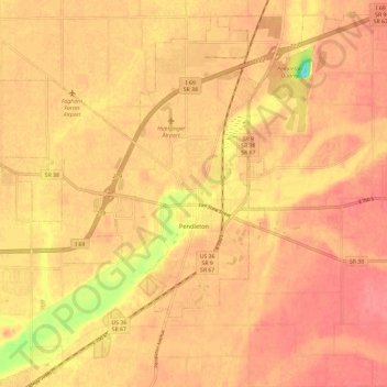
Name: Topografische Karte Pendleton, Höhe, Relief.
Ort: Pendleton, Madison County, Indiana, 46064, United States (39.97625 -85.84306 40.03402 -85.72502)
Durchschnittliche Höhe: 268 m
Minimale Höhe: 219 m
Maximale Höhe: 284 m
Andere topografische Karten
Klicken Sie auf eine Karte, um ihre Topografie, ihre Höhe und ihr Relief anzuzeigen.
Chesterfield
United States > Indiana > Madison County
Chesterfield, Madison County, Indiana, United States
Durchschnittliche Höhe: 277 m
Edgewood
United States > Indiana > Madison County
Edgewood, Madison County, Indiana, United States
Durchschnittliche Höhe: 267 m
Frankton
United States > Indiana > Madison County
Frankton, Madison County, Indiana, United States
Durchschnittliche Höhe: 259 m
Anderson
United States > Indiana > Madison County
Anderson, Madison County, Indiana, United States
Durchschnittliche Höhe: 272 m
Florida
United States > Indiana > Madison County > Florida
Florida, Madison County, Indiana, United States
Durchschnittliche Höhe: 269 m