
Topografische Karte Brule
Klicken Sie auf die Karte, um die Höhe anzuzeigen.
Über diese Karte
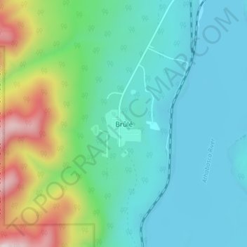
Name: Topografische Karte Brule, Höhe, Relief.
Ort: Brule, Yellowhead County, Alberta, Canada (53.29038 -117.88925 53.33038 -117.84925)
Durchschnittliche Höhe: 1.135 m
Minimale Höhe: 979 m
Maximale Höhe: 1.659 m
Andere topografische Karten
Klicken Sie auf eine Karte, um ihre Topografie, ihre Höhe und ihr Relief anzuzeigen.
Brazeau River Provincial Recreation Area
Canada > Alberta > Yellowhead County
Durchschnittliche Höhe: 1.325 m
William A. Switzer Provincial Park
Canada > Alberta > Yellowhead County
This park is situated within the foothills of Alberta's Rocky Mountains, at an elevation of 1,150 m (3,770 ft) to 1,300 m (4,300 ft) and has a surface of 93 km2 (36 sq mi). It was established on December 22, 1958 and is maintained by Alberta Tourism, Parks and Recreation. The park is named after former…
Durchschnittliche Höhe: 1.348 m