
Topografische Karte Barangay 16
Interaktive Karte
Klicken Sie auf die Karte, um die Höhe anzuzeigen.
Über diese Karte
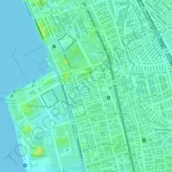
Name: Topografische Karte Barangay 16, Höhe, Relief.
Durchschnittliche Höhe: 7 m
Minimale Höhe: 0 m
Maximale Höhe: 21 m
Andere topografische Karten
Klicken Sie auf eine Karte, um ihre Topografie, ihre Höhe und ihr Relief anzuzeigen.
SM Mall of Asia Complex
SM Mall of Asia Complex, Barangay 76, Zone 10, District 1, Pasay, Southern Manila District, Metro Manila, Philippines
Durchschnittliche Höhe: 3 m
Barangay 42
Barangay 42, District 2, Pasay, Southern Manila District, Metro Manila, Philippines
Durchschnittliche Höhe: 8 m
Barangay 185
Barangay 185, Zone 19, District 2, Pasay, Fourth District, Metro Manila, Philippines
Durchschnittliche Höhe: 10 m
Barangay 186
Barangay 186, Zone 19, District 2, Pasay, Fourth District, Metro Manila, Philippines
Durchschnittliche Höhe: 8 m
Barangay 75
Barangay 75, Zone 10, Pasay, 1st District, Pasay, Metro Manila, 1300, Philippines
Durchschnittliche Höhe: 7 m