
Topografische Karte Umpire
Interaktive Karte
Klicken Sie auf die Karte, um die Höhe anzuzeigen.
Über diese Karte
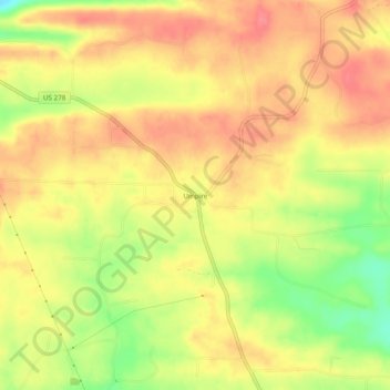
Name: Topografische Karte Umpire, Höhe, Relief.
Ort: Umpire, Howard County, Arkansas, 71971, United States (34.25900 -94.07075 34.29900 -94.03075)
Durchschnittliche Höhe: 260 m
Minimale Höhe: 215 m
Maximale Höhe: 287 m
Andere topografische Karten
Klicken Sie auf eine Karte, um ihre Topografie, ihre Höhe und ihr Relief anzuzeigen.
Saratoga
United States > Arkansas > Howard County
Saratoga, Howard County, Arkansas, 71859, United States
Durchschnittliche Höhe: 106 m
Center Point
United States > Arkansas > Howard County
Center Point, Howard County, Arkansas, United States
Durchschnittliche Höhe: 190 m
Midway
United States > Arkansas > Howard County
Midway, Howard County, Arkansas, United States
Durchschnittliche Höhe: 105 m
Corinth
United States > Arkansas > Howard County
Corinth, Howard County, Arkansas, United States
Durchschnittliche Höhe: 191 m
Athens
United States > Arkansas > Howard County
Athens, Howard County, Arkansas, 71971, United States
Durchschnittliche Höhe: 284 m
Okay
United States > Arkansas > Howard County
Okay, Howard County, Arkansas, 71859, United States
Durchschnittliche Höhe: 90 m
Mineral Springs
United States > Arkansas > Howard County
Mineral Springs, Howard County, Arkansas, United States
Durchschnittliche Höhe: 103 m
Mineola
United States > Arkansas > Howard County
Mineola, Howard County, Arkansas, 71971, United States
Durchschnittliche Höhe: 290 m
Tollette
United States > Arkansas > Howard County
Tollette, Howard County, Arkansas, 71851, United States
Durchschnittliche Höhe: 101 m
Schaal
United States > Arkansas > Howard County
Schaal, Howard County, Arkansas, 71851, United States
Durchschnittliche Höhe: 91 m
Nashville
United States > Arkansas > Howard County
Nashville, Howard County, Arkansas, 71852, United States
Durchschnittliche Höhe: 128 m
Dierks
United States > Arkansas > Howard County
Dierks, Howard County, Arkansas, United States
Durchschnittliche Höhe: 139 m