
Topografische Karte Ballard
Interaktive Karte
Klicken Sie auf die Karte, um die Höhe anzuzeigen.
Über diese Karte
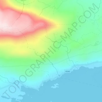
Name: Topografische Karte Ballard, Höhe, Relief.
Durchschnittliche Höhe: 120 m
Minimale Höhe: 3 m
Maximale Höhe: 397 m
Andere topografische Karten
Klicken Sie auf eine Karte, um ihre Topografie, ihre Höhe und ihr Relief anzuzeigen.
Gort
Gort, Gort ED, Loughrea Municipal District, County Galway, Connacht, Irlande
Durchschnittliche Höhe: 25 m
Aille
Aille, Doonbally ED, Tuam Municipal District, County Galway, Connacht, Irlande
Durchschnittliche Höhe: 68 m
Acres
Acres, Killeen ED, Tuam Municipal District, County Galway, Connacht, Irlande
Durchschnittliche Höhe: 73 m
Loughrea
Loughrea, Loughrea Urban ED, Loughrea Municipal District, County Galway, Connacht, Irlande
Durchschnittliche Höhe: 88 m
Clifden (Townland Of)
Clifden (Townland Of), Clifden ED, Conamara Municipal District, County Galway, Connacht, H71 AW08, Irlande
Durchschnittliche Höhe: 52 m
Moycullen
Moycullen, Moycullen ED, Conamara Municipal District, County Galway, Connacht, Irlande
Durchschnittliche Höhe: 10 m
Illion
Illion, Illion ED, Conamara Municipal District, County Galway, Connacht, Irlande
Durchschnittliche Höhe: 184 m
Baie de Galway
Baie de Galway, County Galway, Connacht, Irlande
Durchschnittliche Höhe: 35 m
Gortnarup
Gortnarup, Cloonbur ED, Conamara Municipal District, County Galway, Connacht, Irlande
Durchschnittliche Höhe: 114 m
Aille
Aille, Bearna, Conamara Municipal District, County Galway, Connacht, Irlande
Durchschnittliche Höhe: 51 m
Killeany
Killeany, Árainn, Conamara Municipal District, County Galway, Connacht, H91 P266, Irlande
Durchschnittliche Höhe: 23 m
Bunowen
Bunowen, Cushkillary ED, Conamara Municipal District, County Galway, Connacht, Irlande
Durchschnittliche Höhe: 81 m
Clontuskert
Clontuskert, Ballinasloe Municipal District, County Galway, Connacht, Irlande
Durchschnittliche Höhe: 60 m
Loughrea
Irlande > County Galway > Loughrea
Loughrea, Loughrea Municipal District, County Galway, Connacht, H62KD91, Irlande
Durchschnittliche Höhe: 88 m