
Topografische Karte Milburn
Klicken Sie auf die Karte, um die Höhe anzuzeigen.
Milburn
From an agricultural perspective, however, the Geopark is simply an area of poorly drained grazing that becomes progressively less useful as its altitude increases. Nevertheless, the lower slopes of the inlier are still sufficiently valuable to be enclosed, largely with drystone walling, and are used for grazing sheep and cattle. Fell ponies are also raised here. Immediately above the village, this area is known as Red Carle.
Über diese Karte
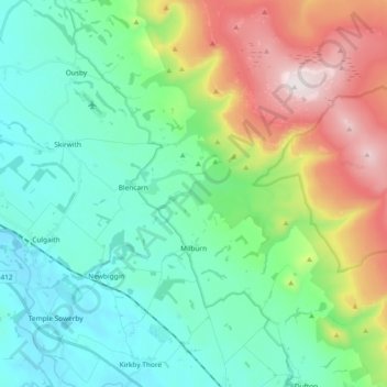
Name: Topografische Karte Milburn, Höhe, Relief.
Ort: Milburn, Westmorland and Furness, England, United Kingdom (54.63878 -2.55894 54.70728 -2.37259)
Durchschnittliche Höhe: 320 m
Minimale Höhe: 92 m
Maximale Höhe: 893 m
Andere topografische Karten
Klicken Sie auf eine Karte, um ihre Topografie, ihre Höhe und ihr Relief anzuzeigen.
Walney Channel
United Kingdom > England > Westmorland and Furness > Roa Island
Durchschnittliche Höhe: 4 m
Pendragon Castle
United Kingdom > England > Westmorland and Furness > Outhgill
Durchschnittliche Höhe: 345 m
Kearstwick
United Kingdom > England > Westmorland and Furness > South Lakeland > Kirkby Lonsdale
Durchschnittliche Höhe: 95 m