
Topografische Karte McKenzie Island
Interaktive Karte
Klicken Sie auf die Karte, um die Höhe anzuzeigen.
Über diese Karte
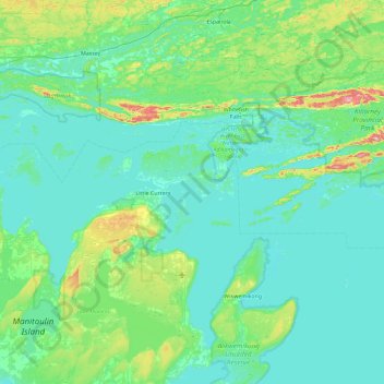
Name: Topografische Karte McKenzie Island, Höhe, Relief.
Durchschnittliche Höhe: 210 m
Minimale Höhe: 169 m
Maximale Höhe: 471 m
Andere topografische Karten
Klicken Sie auf eine Karte, um ihre Topografie, ihre Höhe und ihr Relief anzuzeigen.
Rabbit Island
Canada > Ontario > Manitoulin District > Northeastern Manitoulin and the Islands
Rabbit Island, Northeastern Manitoulin and the Islands, Manitoulin District, Northeastern Ontario, Ontario, Canada
Durchschnittliche Höhe: 187 m
Little Current
Canada > Ontario > Manitoulin District > Northeastern Manitoulin and the Islands
Little Current, Northeastern Manitoulin and the Islands, Manitoulin District, Northeastern Ontario, Ontario, P0P 1K0, Canada
Durchschnittliche Höhe: 193 m