
Vielen Dank für die Unterstützung dieser Website ❤️
Spenden
Spenden
Topografische Karte Moulin de Thibaut
Klicken Sie auf die Karte, um die Höhe anzuzeigen.
Vielen Dank für die Unterstützung dieser Website ❤️
Spenden
Spenden
Über diese Karte
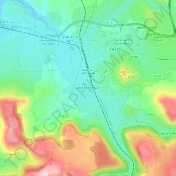
Name: Topografische Karte Moulin de Thibaut, Höhe, Relief.
Durchschnittliche Höhe: 726 m
Minimale Höhe: 644 m
Maximale Höhe: 878 m
Vielen Dank für die Unterstützung dieser Website ❤️
Spenden
Spenden
Andere topografische Karten
Klicken Sie auf eine Karte, um ihre Topografie, ihre Höhe und ihr Relief anzuzeigen.
12150
France > Occitanie > Aveyron > Sévérac d'Aveyron > Sévérac-le-Château
Durchschnittliche Höhe: 815 m