
Topografische Karte Greer County
Interaktive Karte
Klicken Sie auf die Karte, um die Höhe anzuzeigen.
Über diese Karte
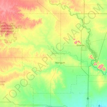
Name: Topografische Karte Greer County, Höhe, Relief.
Ort: Greer County, Oklahoma, United States of America (34.72463 -99.88827 35.11698 -99.24667)
Durchschnittliche Höhe: 504 m
Minimale Höhe: 411 m
Maximale Höhe: 705 m
Andere topografische Karten
Klicken Sie auf eine Karte, um ihre Topografie, ihre Höhe und ihr Relief anzuzeigen.
Skiatook Lake
United States of America > Oklahoma > Morgans Corner
Skiatook Lake, Major General Clarence L. Tinker Memorial Highway, Morgans Corner, Osage County, Oklahoma, United States of America
Durchschnittliche Höhe: 228 m
Porum
United States of America > Oklahoma > Porum
Porum, Muskogee County, Oklahoma, 74455, United States of America
Durchschnittliche Höhe: 181 m
Idabel
United States of America > Oklahoma > Idabel
Idabel, McCurtain County, Oklahoma, 74745, United States of America
Durchschnittliche Höhe: 132 m
Woodall
United States of America > Oklahoma
Woodall, Cherokee County, Oklahoma, United States of America
Durchschnittliche Höhe: 232 m
Guymon
United States of America > Oklahoma > Guymon
Guymon, Texas, Oklahoma, United States of America
Durchschnittliche Höhe: 933 m
Coalgate
United States of America > Oklahoma > Coalgate
Coalgate, Coal County, Oklahoma, 74538, United States of America
Durchschnittliche Höhe: 186 m
Foss
United States of America > Oklahoma > Foss
Foss, Washita County, Oklahoma, United States of America
Durchschnittliche Höhe: 508 m
Wynnewood
United States of America > Oklahoma > Wynnewood
Wynnewood, Oklahoma, 73098, United States of America
Durchschnittliche Höhe: 271 m
Bethany
United States of America > Oklahoma > Bethany
Bethany, Oklahoma County, Oklahoma, United States of America
Durchschnittliche Höhe: 396 m