
Topografische Karte Providence Plantation
Interaktive Karte
Klicken Sie auf die Karte, um die Höhe anzuzeigen.
Über diese Karte
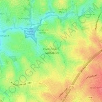
Name: Topografische Karte Providence Plantation, Höhe, Relief.
Durchschnittliche Höhe: 205 m
Minimale Höhe: 174 m
Maximale Höhe: 234 m
Andere topografische Karten
Klicken Sie auf eine Karte, um ihre Topografie, ihre Höhe und ihr Relief anzuzeigen.
Montclaire South
United States > North Carolina > Mecklenburg County > Charlotte
Montclaire South, Charlotte, Mecklenburg County, North Carolina, 28217, United States
Durchschnittliche Höhe: 202 m
Manchester
United States > North Carolina > Mecklenburg County > Charlotte
Manchester, Charlotte, Mecklenburg County, North Carolina, United States
Durchschnittliche Höhe: 234 m
Grierview
United States > North Carolina > Mecklenburg County > Charlotte
Grierview, Charlotte, Mecklenburg County, North Carolina, 28126, United States
Durchschnittliche Höhe: 232 m
Coulwood Hills
United States > North Carolina > Mecklenburg County > Charlotte > Coulwood Hills
Coulwood Hills, Charlotte, Mecklenburg County, North Carolina, 28214, United States
Durchschnittliche Höhe: 213 m
Providence Plantation
United States > North Carolina > Mecklenburg County > Charlotte > Providence Plantation
Providence Plantation, Charlotte, Mecklenburg County, North Carolina, 28270, United States
Durchschnittliche Höhe: 200 m