
Topografische Karte Sardulgarh
Interaktive Karte
Klicken Sie auf die Karte, um die Höhe anzuzeigen.
Sardulgarh
Sardulgarh is located in the south region of Punjab State. The longitude and latitude at 29.697°N 75.238752°E. It has an average elevation of 210 metres (688 feet). It is a city located around the bank of River Ghagar. It is surrounded and touch the border of Haryana State from 3 sides. Its boundary touches to 3 districts (Bathinda, Sirsa and Fatehabad).
Über diese Karte
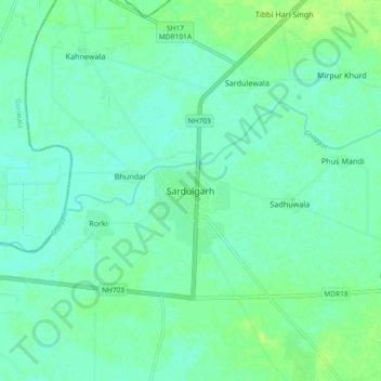
Name: Topografische Karte Sardulgarh, Höhe, Relief.
Durchschnittliche Höhe: 209 m
Minimale Höhe: 204 m
Maximale Höhe: 216 m