
Vielen Dank für die Unterstützung dieser Website ❤️
Spenden
Spenden
Topografische Karte Fatu Hiva
Klicken Sie auf die Karte, um die Höhe anzuzeigen.
Vielen Dank für die Unterstützung dieser Website ❤️
Spenden
Spenden
Fatu Hiva
The mountain rainforest still harbours some endemic plants, such as Ochrosia fatuhivensis and Melicope fatuhivensis (syn. Pelea fatuhivensis), a tree of the Rutaceae family which may already be extinct. Pterophylla tremuloides is an endemic shrub which grows in low ridge top and cliff shrubland with Metrosideros, Dicranopteris and Lycopodium from 700 to 850 metres elevation. A systematic study of the flora with the support of the Smithsonian Institution in 1988 revealed the number of 175 native, 21 endemic, and 136 anthropochoric plants.
Vielen Dank für die Unterstützung dieser Website ❤️
Spenden
Spenden
Über diese Karte
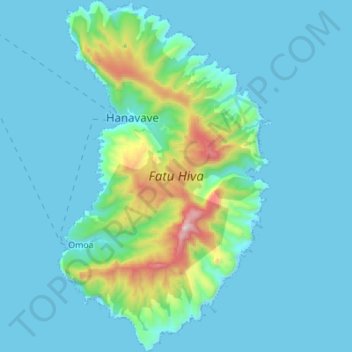
Name: Topografische Karte Fatu Hiva, Höhe, Relief.
Durchschnittliche Höhe: 129 m
Minimale Höhe: -1 m
Maximale Höhe: 1.019 m
Vielen Dank für die Unterstützung dieser Website ❤️
Spenden
Spenden