
Spenden
Topografische Karte Cachoeirinha
Klicken Sie auf die Karte, um die Höhe anzuzeigen.
Spenden
Über diese Karte
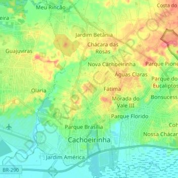
Name: Topografische Karte Cachoeirinha, Höhe, Relief.
Durchschnittliche Höhe: 27 m
Minimale Höhe: 0 m
Maximale Höhe: 81 m
Spenden
Andere topografische Karten
Klicken Sie auf eine Karte, um ihre Topografie, ihre Höhe und ihr Relief anzuzeigen.
Estrada Carlos Dreyer
Brazil > Rio Grande do Sul > Metropolitan Region of Porto Alegre > Igrejinha
Durchschnittliche Höhe: 622 m
Porto Alegre
Brazil > Rio Grande do Sul > Metropolitan Region of Porto Alegre > Porto Alegre
Porto Alegre has a long coastline on the Guaíba Lake, and its topography is punctuated by 40 hills. In the lake, a vast body of water, a maze of islands facing the city creates an archipelago where a unique ecosystem gives shelter to abundant wildlife. The city area concentrates 28% of the native flora of Rio…
Durchschnittliche Höhe: 27 m
Parobé
Brazil > Rio Grande do Sul > Metropolitan Region of Porto Alegre > Parobé > Parobé
Durchschnittliche Höhe: 62 m