
Spenden
Topografische Karte Berlin
Klicken Sie auf die Karte, um die Höhe anzuzeigen.
Spenden
Berlin
Berlin is located at 39°55′17″N 78°57′00″W / 39.9213°N 78.9501°W / 39.9213; -78.9501, approximately 11 miles (18 km) southeast of Somerset and approximately 63 miles (101 km) south-southwest of Altoona. According to the United States Census Bureau, the borough has a total area of 0.9 square miles (2.3 km2), all land. Berlin has an elevation of 2,323 feet (708 m), the second highest, after only Seven Springs, in Pennsylvania.
Spenden
Über diese Karte
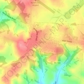
Name: Topografische Karte Berlin, Höhe, Relief.
Ort: Berlin, Somerset County, Pennsylvania, United States (39.91442 -78.96566 39.92719 -78.93737)
Durchschnittliche Höhe: 691 m
Minimale Höhe: 634 m
Maximale Höhe: 729 m
Spenden
Andere topografische Karten
Klicken Sie auf eine Karte, um ihre Topografie, ihre Höhe und ihr Relief anzuzeigen.
Pike's Peak
United States > Pennsylvania > Somerset County > Jenner Township
Durchschnittliche Höhe: 818 m
Hollsopple
United States > Pennsylvania > Somerset County > Conemaugh Township
Durchschnittliche Höhe: 545 m
Kantner
United States > Pennsylvania > Somerset County > Quemahoning Township
Durchschnittliche Höhe: 608 m
Ralphton
United States > Pennsylvania > Somerset County > Quemahoning Township > Ralphton
Durchschnittliche Höhe: 636 m
Spenden
Listie
United States > Pennsylvania > Somerset County > Somerset Township > Listie
Durchschnittliche Höhe: 682 m
Boynton
United States > Pennsylvania > Somerset County > Elk Lick Township > Boynton
Durchschnittliche Höhe: 656 m
Bearwallow Mountain
United States > Pennsylvania > Somerset County > Fairhope Township
Durchschnittliche Höhe: 660 m