
Topografische Karte Grants Pass
Interaktive Karte
Klicken Sie auf die Karte, um die Höhe anzuzeigen.
Über diese Karte
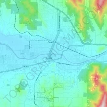
Name: Topografische Karte Grants Pass, Höhe, Relief.
Ort: Grants Pass, Josephine County, Oregon, United States (42.38969 -123.39400 42.47168 -123.28756)
Durchschnittliche Höhe: 374 m
Minimale Höhe: 268 m
Maximale Höhe: 953 m
Andere topografische Karten
Klicken Sie auf eine Karte, um ihre Topografie, ihre Höhe und ihr Relief anzuzeigen.
Grants Pass
United States > Oregon > Josephine County
Grants Pass, Josephine County, Oregon, United States
Durchschnittliche Höhe: 377 m
Provolt
United States > Oregon > Josephine County > Provolt
Provolt, Josephine County, Oregon, United States
Durchschnittliche Höhe: 394 m