
Topografische Karte Kingston
Interaktive Karte
Klicken Sie auf die Karte, um die Höhe anzuzeigen.
Über diese Karte
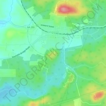
Name: Topografische Karte Kingston, Höhe, Relief.
Ort: Kingston, Bartow County, Georgia, United States (34.21311 -84.95492 34.24689 -84.93351)
Durchschnittliche Höhe: 223 m
Minimale Höhe: 191 m
Maximale Höhe: 298 m
Andere topografische Karten
Klicken Sie auf eine Karte, um ihre Topografie, ihre Höhe und ihr Relief anzuzeigen.
Cartersville
United States > Georgia > Bartow County
Cartersville, Bartow County, Georgia, 30120, United States
Durchschnittliche Höhe: 260 m
Rydal
United States > Georgia > Bartow County
Rydal, Bartow County, Georgia, 30171, United States
Durchschnittliche Höhe: 273 m
Emerson
United States > Georgia > Bartow County
Emerson, Bartow County, Georgia, 30137, United States
Durchschnittliche Höhe: 254 m
Taylorsville
United States > Georgia > Bartow County
Taylorsville, Bartow County, Georgia, United States
Durchschnittliche Höhe: 227 m
White
United States > Georgia > Bartow County
White, Bartow County, Georgia, United States
Durchschnittliche Höhe: 271 m
Euharlee
United States > Georgia > Bartow County
Euharlee, Bartow County, Georgia, United States
Durchschnittliche Höhe: 215 m
Red Top Mountain State Park
United States > Georgia > Bartow County
Red Top Mountain State Park, Bartow County, Georgia, United States
Durchschnittliche Höhe: 276 m
Adairsville
United States > Georgia > Bartow County
Adairsville, Bartow County, Georgia, 30103, United States
Durchschnittliche Höhe: 254 m
Weiss Lake
United States > Georgia > Bartow County > Cartersville
Weiss Lake, Cartersville, Bartow County, Georgia, United States
Durchschnittliche Höhe: 276 m
Emerson
United States > Georgia > Bartow County > Emerson
Emerson, Bartow County, Georgia, 30137, United States
Durchschnittliche Höhe: 266 m