
Vielen Dank für die Unterstützung dieser Website ❤️
Spenden
Spenden
Topografische Karte Tombstone
Klicken Sie auf die Karte, um die Höhe anzuzeigen.
Vielen Dank für die Unterstützung dieser Website ❤️
Spenden
Spenden
Tombstone
The Tombstone District located at 31°42′57″N 110°3′53″W / 31.71583°N 110.06472°W / 31.71583; -110.06472 (31.715940, −110.064827) sits atop a mesa (elevation 4,539 feet ) in the San Pedro River valley between the Huachuca Mountains and Whetstone Mountains to the west, and the Mules and the Dragoon Mountains to the east. According to the United States Census Bureau, the city has a total area of 4.3 square miles (11.2 km2), all land.
Vielen Dank für die Unterstützung dieser Website ❤️
Spenden
Spenden
Über diese Karte
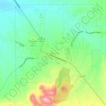
Name: Topografische Karte Tombstone, Höhe, Relief.
Ort: Tombstone, Cochise County, Arizona, 85638, United States (31.69423 -110.08520 31.73423 -110.04520)
Durchschnittliche Höhe: 1.373 m
Minimale Höhe: 1.303 m
Maximale Höhe: 1.517 m
Vielen Dank für die Unterstützung dieser Website ❤️
Spenden
Spenden