
Topografische Karte Bukit Batok Nature Park
Interaktive Karte
Klicken Sie auf die Karte, um die Höhe anzuzeigen.
Bukit Batok Nature Park
The peak of Bukit Batok Hill stands at an elevation of 107m above sea level. Temperature ranges from 23°C to 30°C during "Winter/Wet" season. During Summer, temperature ranges from 24°C to 33°C.
Über diese Karte
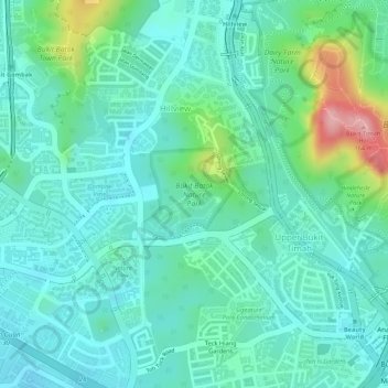
Name: Topografische Karte Bukit Batok Nature Park, Höhe, Relief.
Durchschnittliche Höhe: 45 m
Minimale Höhe: 5 m
Maximale Höhe: 168 m