
Topografische Karte Grass Valley
Interaktive Karte
Klicken Sie auf die Karte, um die Höhe anzuzeigen.
Über diese Karte
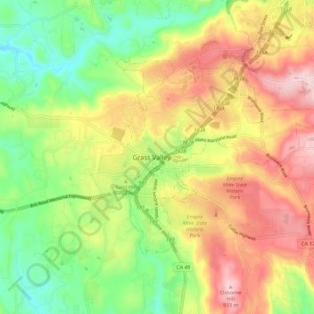
Name: Topografische Karte Grass Valley, Höhe, Relief.
Durchschnittliche Höhe: 767 m
Minimale Höhe: 613 m
Maximale Höhe: 946 m
Grass Valley is a city in Nevada County, California, United States. Situated at roughly 2,500 feet (760 m) elevation in the western foothills of the Sierra Nevada mountain range, this historic northern Gold Country city is 57 miles (92 km) by car from the state capitol in Sacramento, 64 miles (103 km) from Sacramento International Airport, 88 miles (142 km) west of Reno, and 143 miles (230 km) northeast of San Francisco. As of the 2010 United States Census, its population was 12,860.