
Vielen Dank für die Unterstützung dieser Website ❤️
Spenden
Spenden
Topografische Karte Monumento Natural das Portas de Ródão
Klicken Sie auf die Karte, um die Höhe anzuzeigen.
Vielen Dank für die Unterstützung dieser Website ❤️
Spenden
Spenden
Über diese Karte
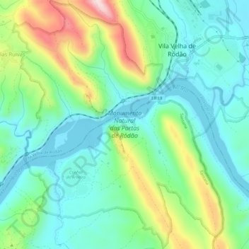
Name: Topografische Karte Monumento Natural das Portas de Ródão, Höhe, Relief.
Durchschnittliche Höhe: 167 m
Minimale Höhe: 69 m
Maximale Höhe: 406 m
Vielen Dank für die Unterstützung dieser Website ❤️
Spenden
Spenden
Andere topografische Karten
Klicken Sie auf eine Karte, um ihre Topografie, ihre Höhe und ihr Relief anzuzeigen.
Rodeios
Portugal > Castelo Branco > Vila Velha de Ródão > Sarnadas de Ródão
Durchschnittliche Höhe: 297 m
Vielen Dank für die Unterstützung dieser Website ❤️
Spenden
Spenden
Barragem Romana da Lameira
Portugal > Castelo Branco > Vila Velha de Ródão > Perais
Durchschnittliche Höhe: 191 m
Vielen Dank für die Unterstützung dieser Website ❤️
Spenden
Spenden
Albufeira de Fratel
Portugal > Castelo Branco > Vila Velha de Ródão > Fratel
Durchschnittliche Höhe: 175 m
Vale de Pousadas
Portugal > Castelo Branco > Vila Velha de Ródão > Perais
Durchschnittliche Höhe: 166 m
Gavião do Ródão
Portugal > Castelo Branco > Vila Velha de Ródão > Gavião do Ródão
Durchschnittliche Höhe: 261 m
Vielen Dank für die Unterstützung dieser Website ❤️
Spenden
Spenden