
Topografische Karte Mountain Village
Interaktive Karte
Klicken Sie auf die Karte, um die Höhe anzuzeigen.
Über diese Karte
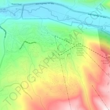
Name: Topografische Karte Mountain Village, Höhe, Relief.
Durchschnittliche Höhe: 2.917 m
Minimale Höhe: 2.629 m
Maximale Höhe: 3.341 m
Mountain Village is a home rule municipality in San Miguel County, southwestern Colorado. It is located just southwest of Telluride, Colorado in the San Juan Mountains. The elevation of the town rises above Telluride to 9,600 feet. The population was 1,264 at the 2020 census.
Andere topografische Karten
Klicken Sie auf eine Karte, um ihre Topografie, ihre Höhe und ihr Relief anzuzeigen.
Telluride
United States > Colorado > San Miguel County
Telluride, San Miguel County, Colorado, 81435, United States
Durchschnittliche Höhe: 3.125 m
Noel
United States > Colorado > San Miguel County
Noel, San Miguel County, Colorado, United States
Durchschnittliche Höhe: 2.774 m
Pandora
United States > Colorado > San Miguel County > Pandora
Pandora, San Miguel County, Colorado, 81435, United States
Durchschnittliche Höhe: 3.174 m
Telluride
United States > Colorado > San Miguel County > Telluride
Telluride, San Miguel County, Colorado, 8145, United States
Durchschnittliche Höhe: 3.246 m
Imogene Pass
United States > Colorado > San Miguel County
Imogene Pass, San Miguel County, Colorado, 81231, United States
Durchschnittliche Höhe: 3.837 m
Telluride Peak
United States > Colorado > San Miguel County
Telluride Peak, San Miguel County, Colorado, 81231, United States
Durchschnittliche Höhe: 3.843 m