
Topografische Karte Kananaskis Improvement District
Interaktive Karte
Klicken Sie auf die Karte, um die Höhe anzuzeigen.
Über diese Karte
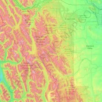
Name: Topografische Karte Kananaskis Improvement District, Höhe, Relief.
Ort: Kananaskis Improvement District, Alberta, Kanada (50.13416 -115.46930 51.13288 -114.32241)
Durchschnittliche Höhe: 1.740 m
Minimale Höhe: 900 m
Maximale Höhe: 3.387 m
Andere topografische Karten
Klicken Sie auf eine Karte, um ihre Topografie, ihre Höhe und ihr Relief anzuzeigen.
Municipality of Jasper
Kanada > Alberta > Division No. 15
Municipality of Jasper, Division No. 15, Alberta, T0E 1E0, Kanada
Durchschnittliche Höhe: 1.789 m
Toronto Peak
Kanada > Alberta > Division No. 15
Toronto Peak, Division No. 15, Alberta, Kanada
Durchschnittliche Höhe: 2.423 m
Crowfoot Glacier
Crowfoot Glacier, Crowfoot Mountain Approach Route, Alberta, Kanada
Durchschnittliche Höhe: 2.550 m
Peyto Glacier
Peyto Glacier, Trapper Peak Route, Columbia-Shuswap Regional District, Alberta, Kanada
Durchschnittliche Höhe: 2.421 m
Lesser Slave River
Lesser Slave River, Township Road 730B, Municipal District of Lesser Slave River, Alberta, Kanada
Durchschnittliche Höhe: 592 m
North Saskatchewan River
North Saskatchewan River, County of Two Hills, Alberta, T5N 1J9, Kanada
Durchschnittliche Höhe: 833 m
Lake Claire
Lake Claire, Census Divsion No. 16, Alberta, Kanada
Durchschnittliche Höhe: 212 m