
Topografische Karte Squaw Mountain
Interaktive Karte
Klicken Sie auf die Karte, um die Höhe anzuzeigen.
Über diese Karte
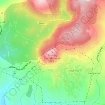
Name: Topografische Karte Squaw Mountain, Höhe, Relief.
Durchschnittliche Höhe: 2.977 m
Minimale Höhe: 2.797 m
Maximale Höhe: 3.174 m
Andere topografische Karten
Klicken Sie auf eine Karte, um ihre Topografie, ihre Höhe und ihr Relief anzuzeigen.
Woodland Park
United States > Colorado > Teller County
Woodland Park, Teller County, Colorado, 80863, United States
Durchschnittliche Höhe: 2.652 m
Victor
United States > Colorado > Teller County
Victor, Teller County, Colorado, United States
Durchschnittliche Höhe: 2.974 m
Midland
United States > Colorado > Teller County
Midland, Teller County, Colorado, United States
Durchschnittliche Höhe: 2.874 m
Cripple Creek
United States > Colorado > Teller County
Cripple Creek, Teller County, Colorado, United States
Durchschnittliche Höhe: 2.946 m
Florissant
United States > Colorado > Teller County
Florissant, Teller County, Colorado, United States
Durchschnittliche Höhe: 2.556 m
Divide
United States > Colorado > Teller County
Divide, Teller County, Colorado, United States
Durchschnittliche Höhe: 2.796 m
Woodland Park
United States > Colorado > Teller County > Woodland Park
Woodland Park, Teller County, Colorado, 80863, United States
Durchschnittliche Höhe: 2.657 m
Copper Mountain
United States > Colorado > Teller County
Copper Mountain, Teller County, Colorado, 80813, United States
Durchschnittliche Höhe: 2.946 m